Former Higashi-Shingi Cable Car 2026-02 ac.jpg
Article

29343 / さんごうちょう

Nara Prefecture 生駒郡

Sango Town

A cable car rests on a station slope.

Former Higashi-Shigi cable car

Photo by Asturio Cantabrio (CC BY-SA 4.0)

01 / Bridge

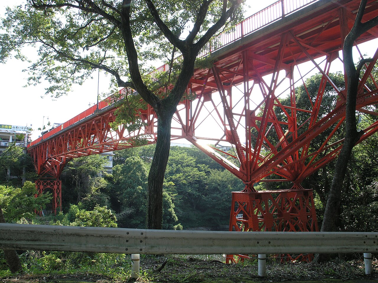
A steel bridge whose trestle piershave few parallels across the country.
Kaiunbashi, Sango, Nara01.JPG
Photo by Kansai explorer (CC BY 3.0)

Kaiunbashi spans a pond at the southern foot of Mt. Shigi: a steel deck cantilever bridge completed in 1931 (Showa 6), 106 m long and 4.2 m wide. Cultural Heritage Online says it served as an approach to the mountain and shows the modernization of pilgrimage to Mt. Shigi. It was registered as a national Registered Tangible Cultural Property in 2007, and its registered location spans Sango and Heguri.

  • 106 m long, 4.2 m wide
  • Completed in 1931 (Showa 6)
  • Registered Tangible Cultural Property, 2007

02 / River boat

Cargo carried over Kamenose wasput on boats at Tatsuno's Yana landing.

魚梁船の復元模型.jpg
Photo by Popbeans (CC BY-SA 4.0)

In the Edo period, Yana boats carried cargo on the Yamato River above Kamenose. Kashiwara City's explanation says goods were carried over the pass to Tatsuno Village and reloaded onto Yana boats at the Yana landing. A boat was 8.5 ken (14.7 m) long and 5 shaku (1.5 m) wide. The photo shows a restored model owned by the Kawai Town Central Public Hall.

  • 8.5 ken (14.7 m) long
  • 5 shaku (1.5 m) wide
  • Yana boats upstream, Kensaki boats downstream

03 / Survey register

Sango, formed of three villages, holdstwo land survey registers of Minamihata.

Sango was formed in 1889 (Meiji 22) when the villages of Tatsuno, Seya and Minamihata merged, and became a town in 1966. The Minamihata registers are the old survey of Bunroku 4 (1595) and the new survey compiled in Empo 7 (1679), both designated by the town. The town records that the Empo register was used as the basis for taxation until 1870.

  • Register of Bunroku 4 (1595)
  • Register compiled in Empo 7 (1679)
  • Two items designated by the town

Living here

From Sango Station, 28 minutes to Tennoji.

  • about 20,000 people
  • Rural district town

The railway stations in town are Sango Station on the JR Kansai Main Line, and Shigisanshita and Seya-Kitaguchi stations on the Kintetsu Ikoma Line. Only local trains stop at Sango Station; by the JR timetable of 14 October 2026, the fastest service running every day takes 28 minutes to Tennoji in the early morning and 36 minutes during the day. The town's access guide names Kintetsu Shigisanshita Station.

People living here
23,219people
19952020

−1.5% since 2015

24,161 → 23,219

Area
8.79km²

5.93km² of it habitable

2024

Households
9,494households

2.4 people per household

2020

Rent (average for rentals)
36,829yen

National average 60,630 yen

2023

Healthcare
2 hospitals / 14 clinics

6.9 per 10,000 people

2023

Area8.79km²Habitable land5.93km² / 67%
Area and habitable land at the same scalee-Stat B1101 / B1103
Children waiting for childcare
—4 nurseries and similar
Home purchase subsidy
—
Average annual temperature
—

These 3 items are waiting on a nationwide data source. We do not fill them with estimates.

Shape

Borders 5 municipalities across 1 prefectures.

Sango Town in Japan34.600°N 135.696°E
TokyoSango Town
Territory of Sango Town
Boundaries: National Land Numerical Information (N03)

North to south

3.5km

Nara Prefecture
平群町, 王寺町, 斑鳩町
Osaka Prefecture
柏原市, 八尾市

Travel times per leg are not published by the municipality, so they are not shown.

Sango Town isthis kind of town.

  1. 01The former Higashi-Shigi cable line was a 1.7 km cable car line from Shigisanshita Station to the former Shigisan Station, built for pilgrims to Mt. Shigi; it opened in 1922 and closed in 1983. The track bed and one car were designated town cultural properties in 2020, and the car stands in front of Shigisanshita Station
  2. 02The name Sango comes from the village formed in 1889 (Meiji 22) by merging Tatsuno, Seya and Minamihata. The Yana landing in Tatsuno was the starting point of river transport on the Yamato River above Kamenose, and the town also has Tatsuta Taisha and the Tatsuta Kodo old road
  3. 03The town's list of cultural properties names, as national Important Cultural Properties, the standing wooden Jizo Bodhisattva of Kannonji, the main hall of Hachiman Shrine in Seya and a Heian-period drum body of Tatsuta Taisha; as prefecturally designated, the former temple layout of the Heiryuji site; and, as town-designated, roof-tile kilns and the line-engraved Yakushi stone Buddha of Jishoin

See the town as it is now.

Source: Wikidata (P2002, P2003, P2013, P2397)

If something caught your eye, ask the town itself.