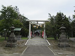
Urausu Shrine, dogtooth violets, Urausu Town
Article

01431 / うらうすちょう

Hokkaido 樺戸郡

Urausu Town

Flowers carpet a shrine on donated land.

Urausu Shrine, dogtooth violets

Photo by DrTerraKhan (CC BY-SA 3.0)

01 / Sapporo soft stone

A stone shop's storehouse andfront differ in stone finish.

The shop is built of Sapporo soft stone. Its storehouse has a finish cut with diagonal ridges, while the shop front is smooth, and the front dates to the early Showa period. The town's booklet says a warehouse by the former station uses stone 15 cm thick, half the shop's 30 cm.

  • Shop front: early Showa period
  • Shop stone: 30 cm thick
  • Station warehouse stone: 15 cm thick

02 / Oxbow lakes

Eight oxbow lakes line upover about 10 km of the Ishikari.

The town's booklet says eight oxbow lakes, large and small, lie in a row over about 10 km, from Pira Numa, the farthest upstream along the Ishikari River, to a pair of lakes at the other end. It calls them naturally formed, in one of the few areas in Japan where they are so dense.

  • Eight oxbow lakes, large and small
  • In a row over about 10 km
  • Naturally formed

03 / Church

The 1897 hall was movedto its present site in 1906.

Church in Urausu Town
Photo by 合田一道 (Public domain)

The town's booklet says a proper hall was built near the oxbow lake Urausu Numa in 1897 and moved to the present site in 1906. The current hall of 1959 was built with volunteer labor by members, and the booklet names the former Sapporo Kita-Ichijo church as its model.

  • 1897: hall built near Urausu Numa
  • 1906: moved to the present site
  • Model: former Sapporo Kita-Ichijo church

Urausu Town from the sky

Now and 1974–78. Tap a photo to zoom in.

Wide (about 6 km across)

Close (about 1.5 km across)

Now (shot September 2009)Shot 1974–78

Source: Geospatial Information Authority of Japan (GSI) GSI Tiles(全国最新写真(シームレス)/国土画像情報(第一期:1974〜1978年撮影))

Open in GSI Maps (now)Open in GSI Maps (1974–78)

Living here

No station; 34 minutes by bus to Takikawa.

  • about 2,000 people
  • Rural district town

There is no railway station in the town; the Sassho Line ran until 2020. The town bus on the Urausu-Takikawa route takes at best 34 minutes from Urausu Town Office stop to Takikawa Station. The town covers 101.83 km2 and says Sapporo is about 65 km away and Asahikawa 70 km.

People living here
1,732people
19952020

−12.7% since 2015

2,854 → 1,732

Area
101.83km²

52.95km² of it habitable

2024

Households
777households

2.2 people per household

2020

Rent (average for rentals)
—
Healthcare
0 hospitals / 3 clinics

17.3 per 10,000 people

2023

Area101.83km²Habitable land52.95km² / 52%
Area and habitable land at the same scalee-Stat B1101 / B1103
Children waiting for childcare
—0 nurseries and similar
Home purchase subsidy
—
Average annual temperature
—

These 3 items are waiting on a nationwide data source. We do not fill them with estimates.

ACCESS

Where you can go from here.

Urausu Town in Japan43.431°N 141.819°E
TokyoOsakaUrausu Town
Urausu Town Office
浦臼町役場2015
  • to TakikawaLocal bus34min

Travel times follow 浦臼町営バス『浦臼滝川線』の時刻表(町公式『交通アクセス』から PDF。『令和8年10月1日現在』)。全日運行の便の最速(浦臼役場前→滝川駅前34分・滝川駅前→浦臼役場前33分) (checked 2026-10-29). They vary by time of day.

Shape

Borders 5 municipalities.

Territory of Urausu Town
Boundaries: National Land Numerical Information (Administrative Area Data), MLIT. Processed by Machigatari.Lakes: National Land Numerical Information (Lake Data), MLIT. Processed by Machigatari. Prepared with the approval of the Director-General of the Geospatial Information Authority of Japan, using its Digital Map 25000 (Spatial Data Framework) and Digital Map 25000 (Place Names and Public Facilities). (承認番号 平27情使、第585号)

Urausu Town isthis kind of town.

  1. 01Urausu Shrine stands on 30,000 tsubo (9.9 hectares) of donated land, with clearing begun in 1898 and the shrine completed in 1910. The town says its grounds are now covered in dogtooth violets and corydalis like a carpet.
  2. 02The stone shop is built of Sapporo soft stone, and its storehouse and front differ in finish. The town's booklet counts eight oxbow lakes in a row over about 10 km on the upstream side of the Ishikari River.
  3. 03There is no railway station in the town, and the town bus reaches Takikawa Station in 34 minutes at best. The church was moved to its present site in 1906 and rebuilt as the present hall in 1959.

If something caught your eye, ask the town itself.