新潟県の重心点.JPG
Article

15211 / みつけし

Niigata Prefecture

Mitsuke City

“Middle of Niigata Prefecture,” it says.

Niigata's center of gravity

Photo by Neotarou (CC BY-SA 4.0)

01 / Mimitori Site

Villages that flourished about 5,000 years ago,about 4,000 years ago and about 2,300 years ago, on one site.

A national historic site on a ridge 76 m above sea level that extends from the Higashiyama Hills on the eastern edge of the Niigata Plain. Settlements of the Middle, Late and Final Jomon periods have been confirmed at this single site. The early Late Jomon ring-shaped settlement measured 200 m north to south and 118 m east to west. The city describes the Late Jomon settlement as the largest in the prefecture, and a jade taishu pendant 10.6 cm long was unearthed from a Middle Jomon building site.

  • National historic site, designated 2015
  • Late Jomon ring settlement, 200 m by 118 m
  • Jade pendant, 10.6 cm long

02 / Imamachi

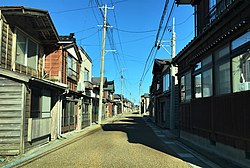
Imamachi, which flourished on boat traffic on the Kariyata River,was a town apart from Mitsuke until 1956.

Central Imamachi 001 March2020.jpg
Photo by Drph17 (CC BY-SA 4.0)

Imamachi flourished on boat traffic on the Kariyata River. In the Edo period people did business by boat and carried tribute rice, and river ports (kawato) developed as well. The Niigata Prefecture Tourism Association describes it as a townscape of river ports that flourished on boat traffic on the Kariyata River. It was merged into Mitsuke in 1956. At the annual Giant Kite Battle in June, kite groups on both banks of the levee entangle hexagonal giant kites, six of the groups from the Imamachi side.

  • Merged into Mitsuke, 1956
  • River ports (kawato)
  • Six kite groups from the Imamachi side

03 / Kannonyama

From a hill about 60 m above sea level,the city lies below and Mount Sumon far to the east.

観音山から望む見附市街.JPG
Photo by Neotarou (CC BY-SA 4.0)

Suidoyama-Kannonyama Park stands on a small hill about 60 m above sea level in the southeast of Mitsuke. To the west the city spreads out below, and far to the east Mount Sumon and Mount Awagatake can be seen. Somei-Yoshino and double-flowered cherry trees line the road, and from mid-June to early July about 10,000 hydrangea plants cover the hillside.

  • About 60 m above sea level
  • About 10,000 hydrangeas
  • Mount Sumon and Mount Awagatake to the east

Living here

Hills in the east, farmland from north to west.

  • about 40,000 people

Mitsuke lies near the middle of Niigata Prefecture, about 300 km from central Tokyo and about 50 km from central Niigata City. The east is forested hills, and the north and west are a plain of farmland; the Kariyata River, part of the Shinano River system, flows through the city as if dividing it north and south. Its textile history began around 1800, and Mitsuke Yuki cloth was becoming known in the last years of the shogunate. The gateway is Mitsuke Station on the JR Shinetsu Line.

People living here
39,237people
19952020

−3.4% since 2015

43,760 → 39,237

Area
77.91km²

49.98km² of it habitable

2024

Households
14,136households

2.8 people per household

2020

Rent (average for rentals)
41,787yen

National average 60,630 yen

2023

Healthcare
1 hospital / 30 clinics

7.9 per 10,000 people

2023

Area77.91km²Habitable land49.98km² / 64%
Area and habitable land at the same scalee-Stat B1101 / B1103
Children waiting for childcare
—11 nurseries and similar
Home purchase subsidy
—
Average annual temperature
—

These 3 items are waiting on a nationwide data source. We do not fill them with estimates.

Shape

Borders 2 municipalities.

Mitsuke City in Japan37.532°N 138.913°E
TokyoOsakaMitsuke City
Territory of Mitsuke City
Boundaries: National Land Numerical Information (N03)Lakes: National Land Numerical Information (Lake Data), MLIT. Processed by Machigatari. Prepared with the approval of the Director-General of the Geospatial Information Authority of Japan, using its Digital Map 25000 (Spatial Data Framework) and Digital Map 25000 (Place Names and Public Facilities). (承認番号 平27情使、第585号)

North to south

14.8km

長岡市, 三条市

Travel times per leg are not published by the municipality, so they are not shown.

Mitsuke City isthis kind of town.

  1. 01The city records the point where a map of Niigata Prefecture balances (37°31′19″N, 138°54′50″E) as the prefecture's center of gravity, and beside that point a spherical gas holder stands with the words "Here is the middle of Niigata Prefecture"
  2. 02Mimitori Site, a national historic site, has settlements of the Middle, Late and Final Jomon periods at one site, and Imamachi, which flourished on boat traffic on the Kariyata River, was merged into Mitsuke in 1956
  3. 03Suidoyama-Kannonyama Park, about 60 m above sea level, has about 10,000 hydrangea plants blooming from mid-June to early July, with Mount Sumon and Mount Awagatake to the east and the city to the west

If something caught your eye, ask the town itself.