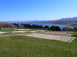
Tate Castle site, moat, Assabu Town
Article

01363 / あっさぶちょう

Hokkaido 檜山郡

Assabu Town

Matsumae's last castle keeps its moat.

Tate Castle site, moat

Photo by Ishii junpei (CC0)

01 / Uzuragawa Japanese white pine

The northern limit of wild goyomatsuis a national natural monument.

Uzuragawa Japanese white pine in Assabu Town
Photo by Ishii junpei (CC0)

The town writes that goyomatsu, common in Honshu mountains, grows in only a small part of Hokkaido, including the Assabu River basin and the Motoura and Horoman river areas in Hidaka. It was designated in 1928; the designated area is now 360 hectares.

  • National natural monument (designated 1928)
  • Designated area now 360 hectares
  • Designation criterion: notable limit of plant distribution

02 / Dobashi Nature Observation Forest

The northern limit of hiba and the southernlimit of todomatsu share one town forest.

The town describes Dobashi Nature Observation Forest as a town-owned forest of about 90 hectares, with hiba cypress at its northern limit, Sakhalin fir at its southern limit and about 560 plant species. Its chronology records a ban on felling, a reserved-forest system, in 1770.

  • About 90 hectares
  • About 560 plant species
  • Felling ban system in 1770

03 / View from Tate Castle site

From the Tate Castle plateau,Mount Otobe, 1,016 m, is in view.

View from Tate Castle site in Assabu Town
Photo by Ishii junpei (CC0)

The town says the north side of the Tate Castle site is a park-like green space, with broad farmland on the plateau. Mount Otobe (1,016 m) can be seen from within, and from the Maruyama hills to the south one can look over the grounds, the Tate district and distant Mount Otobe.

  • Mount Otobe: 1,016 m
  • North side is a park-like green space
  • Grounds seen from Maruyama hills to the south

Assabu Town from the sky

Now and 1974–78. Tap a photo to zoom in.

Wide (about 6 km across)

Close (about 1.5 km across)

Now (shot September–October 2022)Shot 1974–78

Source: Geospatial Information Authority of Japan (GSI) GSI Tiles(全国最新写真(シームレス)/国土画像情報(第一期:1974〜1978年撮影))

Open in GSI Maps (now)Open in GSI Maps (1974–78)

Living here

No station: 51 minutes by bus from Shin-Hakodate-Hokuto.

  • about 4,000 people
  • Rural district town

There is no railway station in town. Hakodate Bus route 610 links Shin-Hakodate-Hokuto Station with a stop in the town center in 51 minutes on its daily services. The town gives 1 hour 50 minutes from Hakodate Station.

People living here
3,592people
19952020

−11.3% since 2015

5,385 → 3,592

Area
460.58km²

91.82km² of it habitable

2024

Households
1,654households

2.2 people per household

2020

Rent (average for rentals)
—
Healthcare
1 hospital / 1 clinic

5.6 per 10,000 people

2023

Area460.58km²Habitable land91.82km² / 20%
Area and habitable land at the same scalee-Stat B1101 / B1103
Children waiting for childcare
—3 nurseries and similar
Home purchase subsidy
—
Average annual temperature
—

These 3 items are waiting on a nationwide data source. We do not fill them with estimates.

ACCESS

Where you can go from here.

Assabu Town in Japan41.921°N 140.226°E
TokyoOsakaAssabu Town
Assabu Town Office
厚沢部町役場2013
  • to Shin-Hakodate-HokutoLocal bus51min

Travel times follow 函館バス公式の停留所時刻表(https://map.hakobus.co.jp/timetable/ の系統データ。ダイヤ『令和8年10月20日』と『令和8年11月9日』の両方を 2026-10-29 に読んだ)。610系統(函館バスセンター~江差ターミナル)の『新函館北斗駅』5番のりば(標柱5・江差ターミナル行き)と『厚沢部』停留所(標柱2・江差ターミナル行き)の時刻を突き合わせた。平日と土曜・日曜・祝日の両方にある便=11:11→12:02・14:35→15:26・16:11→17:02 の3便が、どれも51分。平日だけの7:59→8:50 と 19:45→20:36 の2便(これも51分)は採らない。11/9 改正のダイヤも同じ時刻。 (checked 2026-10-29). They vary by time of day.

Shape

Borders 7 municipalities.

Territory of Assabu Town
Boundaries: National Land Numerical Information (Administrative Area Data), MLIT. Processed by Machigatari.Lakes: National Land Numerical Information (Lake Data), MLIT. Processed by Machigatari. Prepared with the approval of the Director-General of the Geospatial Information Authority of Japan, using its Digital Map 25000 (Spatial Data Framework) and Digital Map 25000 (Place Names and Public Facilities). (承認番号 平27情使、第585号)

Assabu Town isthis kind of town.

  1. 01Tate Castle site is part of the Matsumae Clan Castle Sites; the Agency for Cultural Affairs calls Tate Castle the Matsumae clan's last castle, and a moat, earthworks, well sites and foundation stones remain on a plateau about 200 m on a side
  2. 02The Uzuragawa goyomatsu northern-limit zone, where the tree grows in only a small part of Hokkaido, is a national natural monument, and the town forest Dobashi Nature Observation Forest holds hiba at its northern limit and Sakhalin fir at its southern limit
  3. 03Three-lion folk lion dances are handed down in the Assabu River basin, which the town characterizes by the fight over the female lion, and the town is 51 minutes by Hakodate Bus from Shin-Hakodate-Hokuto Station

If something caught your eye, ask the town itself.