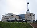
Cape Peshi, Oshidomari Port, Rishirifuji Town
Article

01519 / りしりふじちょう

Hokkaido 利尻郡

Rishirifuji Town

The harbor rock is a lava dome.

Cape Peshi, Oshidomari Port

Photo by 663highland (CC BY 2.5)

01 / Kanro Sensui

Mountain rain and snowmeltwell up on the trail.

Kanro Sensui in Rishirifuji Town
Photo by Koda6029 (CC BY-SA 4.0)

This spring is met soon after setting out on the Oshidomari trail. The Ministry of the Environment's magazine says rain and snowmelt falling on Mount Rishiri soak in and, over a long time, slowly surface as this water. It was chosen as one of Japan's 100 Famous Waters in 1985.

  • One of Japan's 100 Famous Waters, 1985
  • Near the 3rd station of the Oshidomari trail
  • Rain and snowmelt well up

02 / Mount Rishiri

A 1,721 m isolated peakis called Rishirifuji.

Mount Rishiri in Rishirifuji Town
Photo by Koda6029 (CC BY-SA 4.0)

The town's climbing guide introduces Mount Rishiri as an isolated peak 1,721 m high, also called Rishirifuji. Nothing blocks the view from the summit, which offers a 360-degree panorama. The town's chronology records that in 1923 Rishirifuji ranked first among the Three Views of Hokkaido, and a stone monument was raised at Kitami Shrine.

  • 1,721 m high
  • Also called Rishirifuji
  • 1923: first of the Three Views of Hokkaido

03 / Himenuma Pond

Three ponds became one,the island's tourism portal says.

Himenuma Pond in Rishirifuji Town
Photo by 663highland (CC BY-SA 4.0)

The island's tourism portal, Rishiplus, says that in the Taisho era a spring was dammed and the three ponds there were joined into one, making Himenuma. It says the name comes from releasing himemasu salmon, and a walking path of about 1 km runs around it through old-growth forest.

  • Taisho era: spring dammed
  • Three ponds joined into one
  • Walking path, about 1 km

Rishirifuji Town from the sky

Now and 1974–78. Tap a photo to zoom in.

Wide (about 6 km across)

Close (about 1.5 km across)

Now (shot July–August 2017)Shot 1974–78

Source: Geospatial Information Authority of Japan (GSI) GSI Tiles(全国最新写真(シームレス)/国土画像情報(第一期:1974〜1978年撮影))

Open in GSI Maps (now)Open in GSI Maps (1974–78)

Living here

An island town, 100 minutes by ferry from Wakkanai.

  • about 2,000 people
  • Rural district town

There is no railway station in the town, and ferries to the island arrive at Oshidomari Port. From Wakkanai Port, Heartland Ferry takes 100 minutes on every sailing (2026 timetable). The town also gives the Wakkanai to Rishiri trip as 1 hour 40 minutes.

People living here
2,458people
19952020

−11.8% since 2015

4,398 → 2,458

Area
105.62km²

38.51km² of it habitable

2024

Households
1,199households

2.1 people per household

2020

Rent (average for rentals)
—
Healthcare
0 hospitals / 4 clinics

16.3 per 10,000 people

2023

Area105.62km²Habitable land38.51km² / 36%
Area and habitable land at the same scalee-Stat B1101 / B1103
Children waiting for childcare
—2 nurseries and similar
Home purchase subsidy
—
Average annual temperature
—

These 3 items are waiting on a nationwide data source. We do not fill them with estimates.

ACCESS

Where you can go from here.

Rishirifuji Town in Japan45.248°N 141.215°E
TokyoOsakaRishirifuji Town
Rishirifuji Town Office
利尻富士町役場2017
  • to WakkanaiHeart Land Ferry100min

Travel times follow 事業者公式・ハートランドフェリー『時刻表 稚内~利尻島(稚内-鴛泊)』(https://heartlandferry.jp/timetable/ ・2026年1月1日~12月31日のダイヤ・2026-10-29 に開いた)。稚内発→鴛泊着は 1/1~4/27 06:55→08:35・14:00→15:40、4/28~5/31 06:45→08:25・10:10→11:50・14:30→16:10、6/1~9/30 07:15→08:55・11:15→12:55・16:40→18:20、10/1~10/31 06:45→08:25・10:10→11:50・14:30→16:10、11/1~12/31 06:55→08:35・14:00→15:40。どの便も100分(礼文島〈香深〉経由の<>表記の便は2026年の表に無い)。町公式『交通アクセス』(town.rishirifuji.hokkaido.jp/rishirifuji/1416.htm)も『稚内 → 利尻 1時間40分』。事業者と町公式が一致。 (checked 2026-10-29). They vary by time of day.

Shape

Borders 1 municipalities.

Territory of Rishirifuji Town
Boundaries: National Land Numerical Information (Administrative Area Data), MLIT. Processed by Machigatari.Lakes: National Land Numerical Information (Lake Data), MLIT. Processed by Machigatari. Prepared with the approval of the Director-General of the Geospatial Information Authority of Japan, using its Digital Map 25000 (Spatial Data Framework) and Digital Map 25000 (Place Names and Public Facilities). (承認番号 平27情使、第585号)

North to south

17.7km

Rishirifuji Town isthis kind of town.

  1. 01Cape Peshi is a rocky hill beside Oshidomari Port, which the town's chronology counts among the lava domes formed in the island's early volcanic activity. The cape also holds Aizu clansmen's graves and Oshidomari Lighthouse
  2. 02Kanro Sensui, one of Japan's 100 Famous Waters, rises on Mount Rishiri's Oshidomari trail, and the 1,721 m isolated peak is called Rishirifuji. Himenuma was made from three ponds, the island's tourism portal says
  3. 03The town has no railway station; Heartland Ferry runs from Wakkanai Port to Oshidomari Port in 100 minutes

If something caught your eye, ask the town itself.