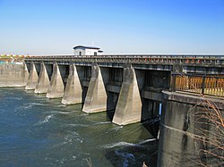
Embankment near Sakai river port, Sakai Town
Article

08546 / さかいまち

Ibaraki Prefecture 猿島郡

Sakai Town

Fuji seen from the embankment in winter.

Embankment near Sakai river port

Photo by Nankou Oronain (as36… (CC BY-SA 3.0)

01 / River wholesalers

A ledger lists mainly rice, tobacco,eggs and tea sent to Edo.

River wholesalers in Sakai Town
Photo by Triglav (CC BY-SA 4.0)

In 1616, the Edo shogunate designated the main river crossings of the Kanto region as official ferry sites, and the Sakai crossing was one of them. The Daifukucho ledger in the Komatsubara Yasunosuke family papers, held by the town's History and Folklore Museum, is a river wholesaler's shipping record. It notes mainly rice, tobacco, eggs, tea and vegetables going to Edo.

  • 1616
  • Komatsubara Yasunosuke family papers
  • A river wholesaler's shipping ledger

02 / Exchange

In 1935, Argentina's envoycame to a village school.

On 19 February 1935, Argentine envoy Montenegro visited Nagata Elementary School, which began the exchange (per the town's museum newsletter). In 1937 the Montenegro Kaikan was built as a local youth training center; it was rebuilt in 2020. The school has held an Argentina Day gathering since 1989.

  • Visit on 19 February 1935
  • Youth training center built 1937
  • Argentina Day gathering since 1989

03 / Pedestal

Said to be Iemitsu's gift to a Tsukuba temple,it is said to have passed to a Sakai temple.

A raihan is a pedestal one steps onto to worship the Buddha. This one is black lacquer with a red border, its four sides in red and gold paint, with gilt chrysanthemum and arabesque fittings. The back bears the inscription "Kan'ei Mizunoto-tori", and it is said to have been donated in 1633 by Iemitsu to a temple on Mt. Tsukuba. It is a prefecturally designated craft.

  • Black lacquer, red border
  • Gilt chrysanthemum and arabesque fittings
  • Back inscription "Kan'ei Mizunoto-tori"

Sakai Town from the sky

Now and 1974–78. Tap a photo to zoom in.

Wide (about 6 km across)

Close (about 1.5 km across)

Now (shot February 2023)Shot 1974–78

Source: Geospatial Information Authority of Japan (GSI) GSI Tiles(全国最新写真(シームレス)/国土画像情報(第一期:1974〜1978年撮影))

Open in GSI Maps (now)Open in GSI Maps (1974–78)

Living here

93 minutes from Tokyo Station by highway bus.

  • about 20,000 people
  • 2 hours to a city centre
  • Rural district town

The town has no railway station, and its gateway is the highway bus terminal. In the town's timetable, all eight down services from Tokyo Station (Yaesu South Exit, bay 3) take 93 minutes, with no difference between weekdays and weekends or holidays (checked 22 October 2026).

People living here
24,201people
19952020

−1.3% since 2015

27,237 → 24,201

Area
46.59km²

43.97km² of it habitable

2024

Households
8,722households

2.8 people per household

2020

Rent (average for rentals)
47,540yen

National average 60,630 yen

2023

Healthcare
1 hospital / 12 clinics

5.4 per 10,000 people

2023

Area46.59km²Habitable land43.97km² / 94%
Area and habitable land at the same scalee-Stat B1101 / B1103
Children waiting for childcare
—5 nurseries and similar
Home purchase subsidy
—
Average annual temperature
—

These 3 items are waiting on a nationwide data source. We do not fill them with estimates.

ACCESS

Where you can go from here.

Sakai Town in Japan36.108°N 139.795°E
OsakaSakai Town
  • to TokyoHighway bus93min

Travel times follow 境町公式『高速バス 境町〜東京駅線(王子駅経由)』(地方創生課。時刻表は令和8年10月31日までの現行と、11月1日からの改正後を並記)の下り(東京駅 八重洲南口3番のりば発→境町高速バスターミナル着)。関東鉄道の路線ページ『境町〜東京駅線』が『全日』運行・『座席は先着順による定員制ですので、予約はできません』と書くことと、ジェイアールバス関東の『【境町線】11/1/(日)ダイヤ改正を行います』(2026-10-05付)で、運行中であることを確かめた (checked 2026-10-22). They vary by time of day.

Shape

Borders 4 municipalities across 1 prefectures.

Territory of Sakai Town
Boundaries: National Land Numerical Information (Administrative Area Data), MLIT. Processed by Machigatari.Lakes: National Land Numerical Information (Lake Data), MLIT. Processed by Machigatari. Prepared with the approval of the Director-General of the Geospatial Information Authority of Japan, using its Digital Map 25000 (Spatial Data Framework) and Digital Map 25000 (Place Names and Public Facilities). (承認番号 平27情使、第585号)

North to south

10.9km

Ibaraki Prefecture
Bando City, Koga City, Goka Town
Chiba Prefecture
Noda City

Sakai Town isthis kind of town.

  1. 01The embankment near the Sakai river port on the Tone River was selected in 2004 as one of the Kanto Fuji-mi Hyakkei, or 100 Fuji views of Kanto, by the Kanto Regional Development Bureau
  2. 02A river wholesaler's ledger records mainly rice, tobacco, eggs and tea shipped to Edo
  3. 03A visit by Argentina's envoy to Nagata Elementary School in 1935 began the exchange

See the town as it is now.

Source: Wikidata (P2002, P2003, P2013, P2397)

If something caught your eye, ask the town itself.