Tukiyama03.jpg
Article

39424 / おおつきちょう

Kochi Prefecture 幡多郡

Otsuki Town

The sea guardian's stone is a crescent.

Tsukiyama Shrine, Bangai Temple

Photo by Dokudami (CC BY-SA 4.0)

01 / Kashiwajima Stone Embankment (柏島石堤)

An embankment wraps the village against waves,and another runs about 310m toward the far shore.
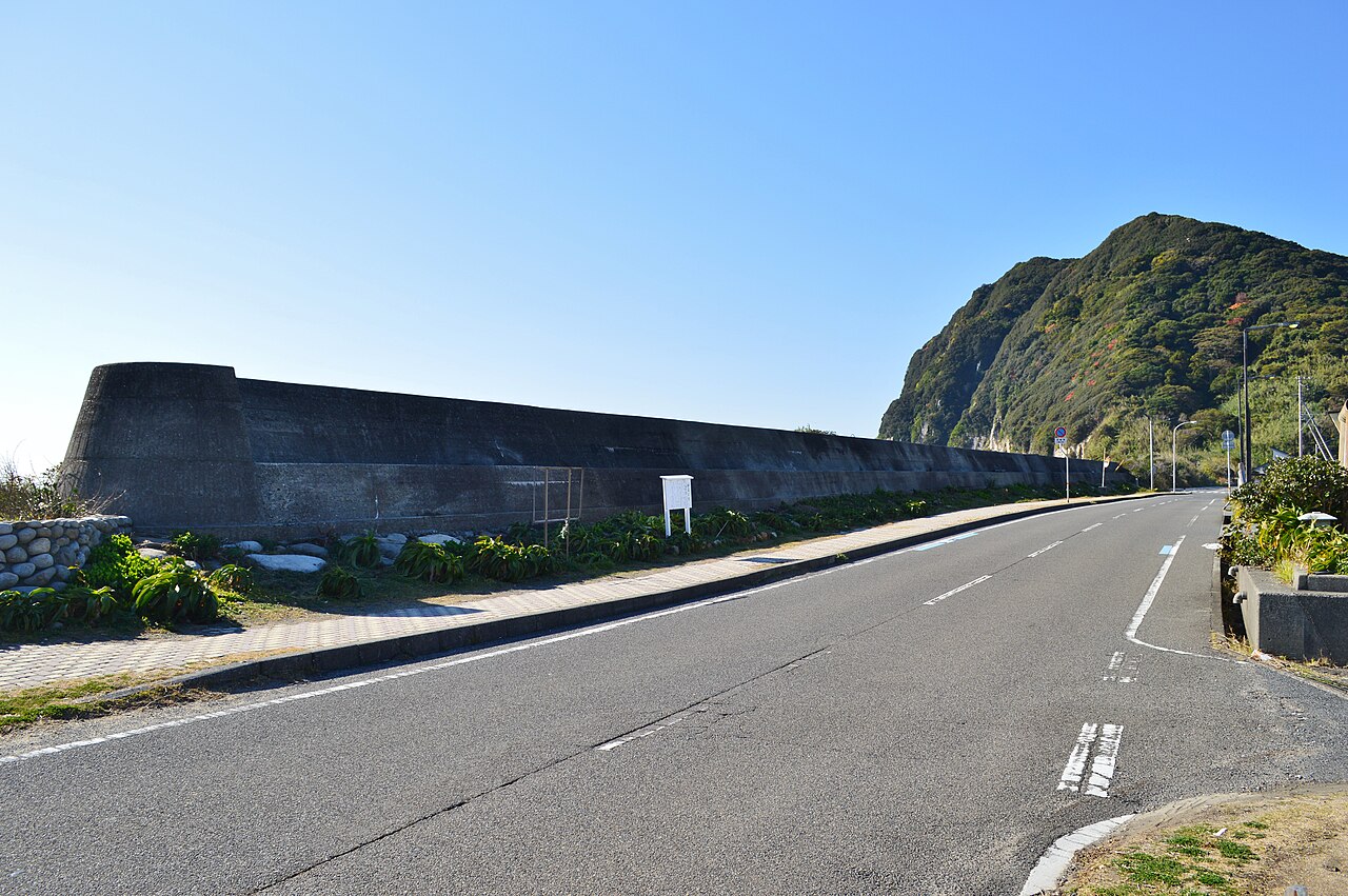
Kashiwajima (Otsuki), sekitei.jpg
Photo by Saigen Jiro (CC0)

Prefectural historic site. The prefecture's description says Nonaka Kenzan, chief administrator of Tosa Domain, built the stone embankment over about seven years from the Jōō era (1652-55). Rebuilt since, it no longer has its original form, but its scale and shape are those of the time, and stonework from Kenzan's day remains at the base.

  • Kochi Prefecture Historic Site (designated January 29, 1953)
  • Embankment around the village about 700m; the one extended toward the far shore about 310m (Prefectural Board of Education)
  • About seven years from the Jōō era (1652-1655) (Prefectural Board of Education)

02 / Ryugasako Karajishi Odori (竜ヶ迫唐獅子おどり)

The tegai-ko who handles the lionalso beats the big drum.

A prefecturally designated intangible folk cultural property. In Ryugasako, settled by people from Ehime Prefecture, a peddler from Ehime is said to have taught local youths the dance in 1892 (Meiji 25). The name karajishi (唐獅子) also comes from the Uwa region of Ehime. The tegai-ko (テガイ子), who handles the lion, calms it with the big drum.

  • Kochi Prefecture Protected Intangible Folk Cultural Property (designated August 8, 1969)
  • Held by the Otsuki Town Local Performing Arts Preservation Society
  • Said to have been practiced with a pot lid in place of a lion head

03 / Kannon-iwa at Odo Coast (大堂海岸の観音岩)

A granite rock that seems to rise from the sealooks like the bodhisattva Kannon.

Odo Kaigan 06.jpg
Photo by Reggaeman (CC BY-SA 3.0)

A granite rock about 30m high, named Kannon-iwa (観音岩) for its resemblance to the bodhisattva Kannon. A legend says it once lit ships passing offshore. Just to the east, Oman-no-taki (お万の滝) is not a waterfall with flowing water; the name comes from the local word for a cliff, "taki" (滝).

  • Kannon-iwa: granite rock about 30m high (Otsuki Tourism Association)
  • Oman-no-taki: a cliff without flowing water
  • A scenic spot of Ashizuri-Uwakai National Park

Living here

At the southwestern tip of Shikoku,the Bungo Channel to the west, the Pacific to the south.

  • about 4,000 people
  • Rural district town

Otsuki lies at the southwestern tip of Kochi Prefecture, between Sukumo and Tosashimizu. It was born on February 11, 1957 (Showa 32) from the merger of the former Ouchi Town and Tsukinada Village, and about 70% of its total area is forest around Mt. Ohora (465m). Agriculture and fishing are its main industries, and its aquaculture raises bluefin tuna and yellowtail.

People living here
4,434people
19952020

−13% since 2015

7,422 → 4,434

Area
102.73km²

22.35km² of it habitable

2024

Households
2,198households

2.0 people per household

2020

Rent (average for rentals)
—
Healthcare
1 hospital / 1 clinic

4.5 per 10,000 people

2023

Area102.73km²Habitable land22.35km² / 22%
Area and habitable land at the same scalee-Stat B1101 / B1103
Children waiting for childcare
—3 nurseries and similar
Home purchase subsidy
—
Average annual temperature
—

These 3 items are waiting on a nationwide data source. We do not fill them with estimates.

Shape

Borders 2 municipalities.

Otsuki Town in Japan32.841°N 132.707°E
TokyoOsakaOtsuki Town
Territory of Otsuki Town
Boundaries: National Land Numerical Information (N03)

North to south

16.1km

宿毛市, 土佐清水市

Travel times per leg are not published by the municipality, so they are not shown.

Otsuki Town isthis kind of town.

  1. 01Tsukiyama Shrine stands in one of the town's districts (才角), and its sacred object is a crescent-shaped stone. Once a mixed Shinto-Buddhist sanctuary called Shugetsuzan Gakko-in Nansho-ji (守月山月光院南照寺), it is presented by the town as guardian of Otsuki's sea and as a bangai site of the Shikoku 88-temple pilgrimage, never short of worshippers.
  2. 02Kashiwajima has a prefectural historic-site stone embankment that shields the village from waves, and Ryugasako has a prefecturally designated karajishi dance. Kannon-iwa at Odo Coast is a granite rock about 30m high, and the Otsuki Tourism Association lists Odo Coast as a scenic spot of Ashizuri-Uwakai National Park.
  3. 03About 400 people live on Kashiwajima, about 4km around. It is also the birthplace of Oe Taku (1847-1921), a prefectural official of Kanagawa who directed the Maria Luz incident.

If something caught your eye, ask the town itself.