Iwanuma Church, stone chapel, Iwanuma City
Article

04211 / いわぬまし

Miyagi Prefecture

Iwanuma City

A chapel with exposed stone masonry.

Iwanuma Church, stone chapel

Photo by Suikotei (CC BY 4.0)

01 / Prefectural cultural property

The all-zelkova karamon gate is thoughtto have been built in Tenpo 13 (1842).
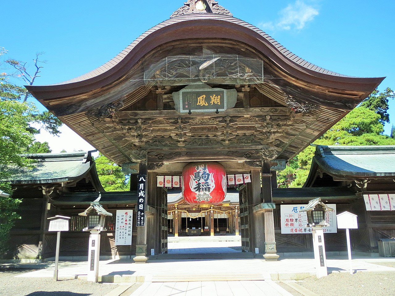
Prefectural cultural property in Iwanuma City
Photo by Ty19080914 (CC BY-SA 4.0)

A one-bay, four-legged gate stands on a stone-paved base in front of the worship hall of Takekoma Shrine. It is rich in carving: a cloud dragon on the gable wall, waves on the transom, and Chinese lions on the beam ends. It measures 5.43 m in both width and depth, and the city's newsletter says the roof weighs 40 tons. From the year carved on a pillar, it is thought to date from Tenpo 13 (1842).

  • 5.43 m in width and depth
  • Roof weight 40 tons
  • Prefectural tangible cultural property (structure)
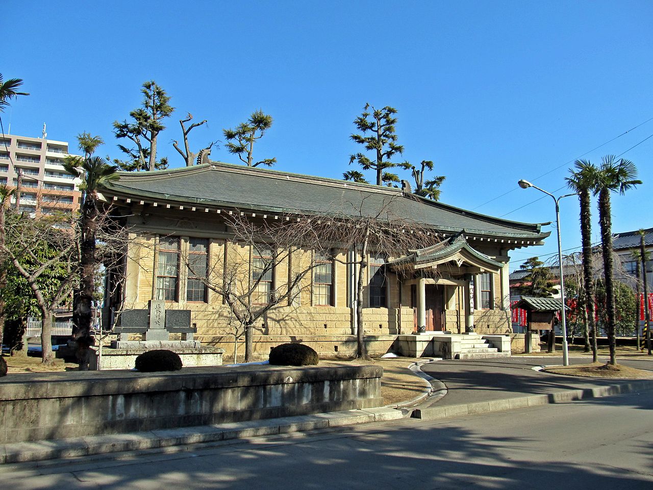
02 / Registered cultural property

Reinforced-concrete base, wooden above,with a horse-shaped shibi on the roof.

Registered cultural property in Iwanuma City
Photo by Bachstelze (CC BY-SA 3.0)

Standing in the grounds of Takekoma Shrine, this building dates from 1938 (Showa 13). Its base and floor are reinforced concrete and the upper part is a single-story wooden structure, with Japanese-style details such as the shibi roof ornament, gegyo hanging ornament and kaerumata brace. Stone from Akiu in Sendai is also fixed to it.

  • 1938 (Showa 13)
  • Wooden, single-story, copper roof
  • National registered tangible cultural property (2021)

03 / Pebble sutra stones

About 40,000 stones, each inscribedwith sutra characters, in two mounds.

In front of Chotokuji Temple, small stones bearing writing were found at two places about 4.5 m apart. The characters of the Lotus Sutra are written on them one by one, about 40,000 stones in all across the two mounds. Both date to the Edo period, and the city says two mounds had not before been found this close together in the prefecture.

  • About 40,000 stones
  • Two mounds about 4.5 m apart
  • Edo-period sutra mounds

Iwanuma City from the sky

Now and 1974–78. Tap a photo to zoom in.

Wide (about 6 km across)

Close (about 1.5 km across)

Now (shot July 2022)Shot 1974–78

Source: Geospatial Information Authority of Japan (GSI) GSI Tiles(全国最新写真(シームレス)/国土画像情報(第一期:1974〜1978年撮影))

Open in GSI Maps (now)Open in GSI Maps (1974–78)

Living here

257 minutes from Ueno by Limited Express Hitachi.

  • about 40,000 people

The Limited Express Hitachi No. 21 on the JR Joban Line runs from Ueno to Iwanuma Station without a change in 257 minutes, and from Tokyo in 264 minutes (fastest daily service in the November 2026 timetable). The city's guide gives 20 minutes by the Tohoku Main Line from Sendai Station to Iwanuma Station.

People living here
44,068people
19952020

−1.4% since 2015

40,072 → 44,068

Area
60.45km²

47.9km² of it habitable

2024

Households
17,251households

2.6 people per household

2020

Rent (average for rentals)
48,116yen

National average 60,630 yen

2023

Healthcare
5 hospitals / 31 clinics

8.2 per 10,000 people

2023

Area60.45km²Habitable land47.9km² / 79%
Area and habitable land at the same scalee-Stat B1101 / B1103
Children waiting for childcare
—10 nurseries and similar
Home purchase subsidy
—
Average annual temperature
—

These 3 items are waiting on a nationwide data source. We do not fill them with estimates.

ACCESS

Where you can go from here.

Iwanuma City in Japan38.104°N 140.870°E
TokyoOsakaIwanuma City
Iwanuma Station
岩沼駅2022
  • to TokyoLtd. exp. Hitachi264min
  • to UenoLtd. exp. Hitachi257min

Travel times follow JR東日本の駅の時刻表(2026年11月号=2611版)上野駅(tt0204)の常磐線 下り 平日・土曜休日の時刻表から特急ひたち21号(列車番号21M・品川-仙台)の列車ページを読み、東京・上野の発から岩沼の着までを数えた(下り=都市→町)。 (checked 2026-10-27). They vary by time of day.

Shape

Borders 4 municipalities.

Territory of Iwanuma City
Boundaries: National Land Numerical Information (Administrative Area Data), MLIT. Processed by Machigatari.Lakes: National Land Numerical Information (Lake Data), MLIT. Processed by Machigatari. Prepared with the approval of the Director-General of the Geospatial Information Authority of Japan, using its Digital Map 25000 (Spatial Data Framework) and Digital Map 25000 (Place Names and Public Facilities). (承認番号 平27情使、第585号)

Iwanuma City isthis kind of town.

  1. 01Iwanuma Church of the United Church of Christ in Japan is a stone church that combines a rectangular chapel with a square tower, newly built in 1930 (Showa 5) and a national registered tangible cultural property
  2. 02Takekoma Shrine has a prefecturally designated karamon gate and a nationally registered museum building, and the Takekuma Pine is one of the national scenic spots "Scenic Sites of the Narrow Road to the Deep North"
  3. 03About 40,000 pebble sutra stones were found in front of Chotokuji Temple, and the city's cultural property newsletter also covers the hill name Nanasaki and a pair of plaques at an Atago shrine in the city

If something caught your eye, ask the town itself.