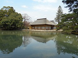
Kirigome, Sendai Domain's kiln, Kami Town
Article

04445 / かみまち

Miyagi Prefecture 加美郡

Kami Town

At a kiln the domain later ran, blue landscapes were painted.

Kirigome, Sendai Domain's kiln

Photo by Gryffindor (CC0)

01 / Mountain

The mountain jutting from the western edge of the Osaki Plainis called "Kami Fuji."

Mountain in Kami Town
Photo by Kumamushi (CC BY-SA 3.0)

Mount Yakurai is 553.1 m high. The town says no other mountains stand around it and the summit gives a full view of the Osaki Plain. Beech and other forests remain and are designated town natural monuments. A sunset meeting the summit, "Diamond Yakurai," occurs only twice a year, spring and autumn, it says.

  • 553.1 m high
  • Beech forests, town natural monument (2005)
  • Sunset meets the summit twice a year (town)

02 / Samurai house

The house of Matsumoto, a senior retainer of the Okuyama familyof Sendai Domain, is one of the houses that separate main house and earthen floor.

The thatched, hipped-roof house has a main house and an earthen-floored space under one continuous roof. It is said to have been a retainer's residence in the time of the Furuuchi family, local lords from 1694 to 1757, before the Okuyama family came. It was designated an Important Cultural Property in 1971.

  • Important Cultural Property, 1971
  • Hipped roof, thatched
  • Main house and earthen floor

03 / Tetsugyo

Tetsugyo fish live in schools in a pondringed by primeval beech forest.

The tetsugyo have long fins, especially the tail fin, and are iron-colored or rust-colored. Genetic studies found them to be a mutant form of crucian carp. The town calls such schools extremely rare. The pond covers about 3.3 ha, edged by wet forests of wingnut and ash trees.

  • Habitat designated a national natural monument, 1933
  • Area about 3.3 ha
  • Mutant form of crucian carp

Kami Town from the sky

Now and 1974–78. Tap a photo to zoom in.

Wide (about 6 km across)

Close (about 1.5 km across)

Now (shot November 2023)Shot 1974–78

Source: Geospatial Information Authority of Japan (GSI) GSI Tiles(全国最新写真(シームレス)/国土画像情報(第一期:1974〜1978年撮影))

Open in GSI Maps (now)Open in GSI Maps (1974–78)

Living here

Twenty-four minutes by local bus from Furukawa Station.

  • about 20,000 people
  • Rural district town

There is no railway station in the town. On the Miyako Bus Shikama line, the fastest daily bus from in front of Furukawa Station on the Tohoku Shinkansen to the Nakaniida area takes 24 minutes (timetable revised May 18, 2026). The town covers 460.67 km2, and its western mountains and hills are designated heavy-snow areas.

People living here
21,943people
20052020

−7.6% since 2015

27,212 → 21,943

Area
460.67km²

131.81km² of it habitable

2024

Households
7,641households

2.9 people per household

2020

Rent (average for rentals)
35,019yen

National average 60,630 yen

2023

Healthcare
0 hospitals / 22 clinics

10.0 per 10,000 people

2023

Area460.67km²Habitable land131.81km² / 29%
Area and habitable land at the same scalee-Stat B1101 / B1103
Children waiting for childcare
—5 nurseries and similar
Home purchase subsidy
—
Average annual temperature
—

These 3 items are waiting on a nationwide data source. We do not fill them with estimates.

ACCESS

Where you can go from here.

Kami Town in Japan38.572°N 140.855°E
TokyoOsakaKami Town
Kami Town Office
加美町役場2015
  • to FurukawaLocal bus24min

Travel times follow 町公式『ミヤコ-バス時刻表』(更新日2026-06-09)が載せるミヤコーバスの2路線。①色麻線(古川駅前〜西古川〜中新田〜色麻町役場。令和8年5月18日改正の時刻表PDFを画像から読んだ):下り・平日は古川駅前 6:40・7:20・8:00・8:35・10:02 発→中新田岡町 7:04・7:44・8:24・8:59・10:26 着(すべて24分。11:45発は大崎市民病院経由で12:16着=31分)、土日祝は古川駅前 6:55・7:50・10:00・13:00・14:30・17:05 発→中新田岡町 7:19・8:14・10:24・13:24・14:54・17:29 着(すべて24分)。 2026-10-28 に下り時刻表の画像(令和8年5月18日改正)を目で見て、平日の古川駅前6:40→中新田岡町7:04・7:20→7:44・8:00→8:24・8:35→8:59・10:02→10:26、土日祝の6:55→7:19ほかがすべて24分と確かめた。 (checked 2026-10-28). They vary by time of day.

Shape

Borders 4 municipalities across 1 prefectures.

Territory of Kami Town
Boundaries: National Land Numerical Information (Administrative Area Data), MLIT. Processed by Machigatari.Lakes: National Land Numerical Information (Lake Data), MLIT. Processed by Machigatari. Prepared with the approval of the Director-General of the Geospatial Information Authority of Japan, using its Digital Map 25000 (Spatial Data Framework) and Digital Map 25000 (Place Names and Public Facilities). (承認番号 平27情使、第585号)

North to south

28.1km

Miyagi Prefecture
Osaki City, Shikama Town
Yamagata Prefecture
Obanazawa City, Mogami Town

Kami Town isthis kind of town.

  1. 01Kirigome ware was fired mainly as porcelain at Kirigome in Miyazaki, became a Sendai Domain enterprise in 1854 and the kiln closed in 1879. The photo shows a display at the Aichi Prefectural Ceramic Museum
  2. 02Mount Yakurai, 553.1 m, is called Kami Fuji, and the Matsumoto residence, used by a senior retainer of the Okuyama family, is a thatched Important Cultural Property
  3. 03Tetsugyo, a mutant form of crucian carp, live in schools in Yutori Pond, whose habitat is a national natural monument

If something caught your eye, ask the town itself.