Komoro Castle Otemon, Tile Gate, Komoro City
Article

20208 / こもろし

Nagano Prefecture

Komoro City

They say rare tiles named it Tile Gate.

Komoro Castle Otemon, Tile Gate

Photo by さかおり (CC BY-SA 4.0)

01 / Wind caves

Ice, and silkworm eggs too:the village's wind caves chilled and stored them.

Wind caves in Komoro City
Photo by Komoro no kaze (CC BY-SA 4.0)

Koori is a hamlet on a slope of the cliff line along the Chikuma River. The Komoro Tourism Bureau says a document from the Genroku era records that ice was stored in a wind cave and presented to the domain lord, and that a silkworm-egg storage business using the caves was founded in 1874 (Meiji 7). Silkworm-egg storage ended in 1932 (Showa 7).

  • Ice stored, per a Genroku-era document
  • Silkworm-egg storage firm, 1874-1932
  • Silkworm eggs

02 / Natural monument

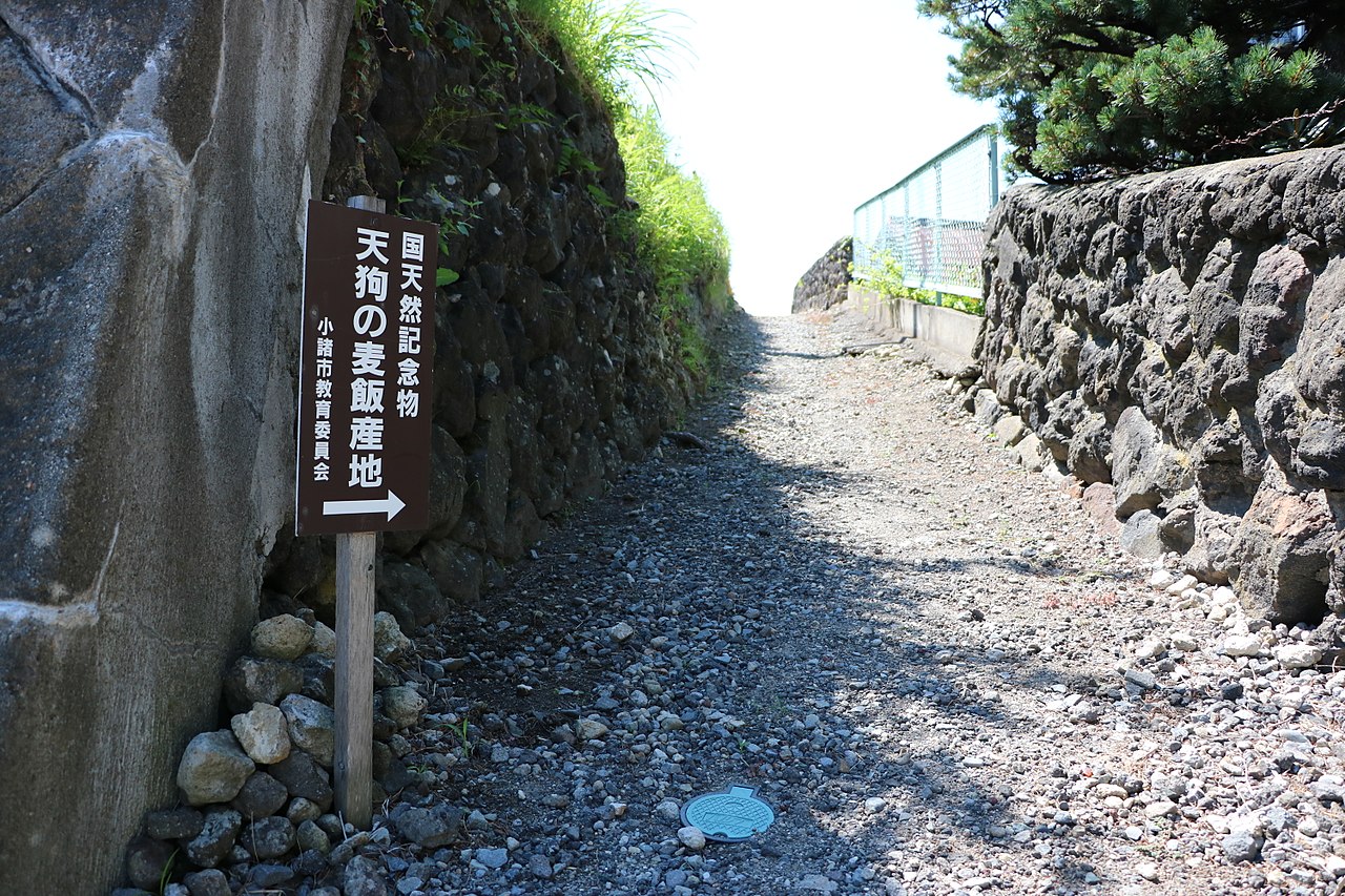
Theories of its cause moved from fungito lower algae to a microbial mass.

Natural monument in Komoro City
Photo by さかおり (CC BY-SA 4.0)

According to the Kojien dictionary, tengu-no-mugimeshi is a yellow-brown, gelatinous mass said to be a complex of blue-green algae, bacteria and fungi. Komoro City says theories of its cause shifted from fungi to lower algae to a microbial aggregate, and the research is not complete. The name first appears in the Zenkoji-michi Meisho Zue of 1843 (Tenpo 14).

  • National Natural Monument, 1921
  • Name first appears in 1843 (Tenpo 14)
  • Said to be a complex of blue-green algae, bacteria and fungi

03 / Building

The principal's old study is a thatched,pavilion-style house with a veranda around its upper floor.

Building in Komoro City
Photo by Komoro no kaze (CC BY-SA 4.0)

Suimeiro is a two-story thatched wooden building on the western slope south of the Komoro Castle site. The Agency for Cultural Affairs describes it as the former study of Kimura Kumaji, principal of Komoro Gijuku, with a veranda along the south and west sides of the second floor, and as a pavilion-style building with a fine view that Shimazaki Toson and others visited. It was registered as a Tangible Cultural Property (building) in July 2026.

  • Former study of Kimura Kumaji
  • Veranda on the south and west of the second floor
  • Registered Tangible Cultural Property (building), 2026

Komoro City from the sky

Now and 1974–78. Tap a photo to zoom in.

Wide (about 6 km across)

Close (about 1.5 km across)

Now (shot November–December 2019)Shot 1974–78

Source: Geospatial Information Authority of Japan (GSI) GSI Tiles(全国最新写真(シームレス)/国土画像情報(第一期:1974〜1978年撮影))

Open in GSI Maps (now)Open in GSI Maps (1974–78)

Living here

From Busta Shinjuku to Komoro Station, with no change.

  • about 40,000 people

According to the JR Bus Kanto timetable (revised September 1, 2026), highway buses run daily from Busta Shinjuku to Komoro Station, four a day, and the fastest takes 190 minutes. The Hokuriku Shinkansen does not stop in Komoro; change at Karuizawa or Sakudaira. Komoro Station, shared by the Shinano Railway and the JR Koumi Line, is the gateway.

People living here
40,991people
19952020

−3.6% since 2015

45,711 → 40,991

Area
98.55km²

64.64km² of it habitable

2024

Households
16,831households

2.4 people per household

2020

Rent (average for rentals)
41,599yen

National average 60,630 yen

2023

Healthcare
2 hospitals / 31 clinics

8.1 per 10,000 people

2023

Area98.55km²Habitable land64.64km² / 66%
Area and habitable land at the same scalee-Stat B1101 / B1103
Children waiting for childcare
—10 nurseries and similar
Home purchase subsidy
—
Average annual temperature
—

These 3 items are waiting on a nationwide data source. We do not fill them with estimates.

ACCESS

Where you can go from here.

Komoro City in Japan36.328°N 138.426°E
OsakaKomoro City
Komoro Station
小諸駅2021
  • to ShinjukuHighway bus190min

Travel times follow ジェイアールバス関東 デジタル時刻表「新宿~佐久・小諸」(2026年9月1日改正・下り上りとも「全日」) (checked 2026-10-21). They vary by time of day.

Shape

Borders 4 municipalities across 1 prefectures.

Territory of Komoro City
Boundaries: National Land Numerical Information (Administrative Area Data), MLIT. Processed by Machigatari.Lakes: National Land Numerical Information (Lake Data), MLIT. Processed by Machigatari. Prepared with the approval of the Director-General of the Geospatial Information Authority of Japan, using its Digital Map 25000 (Spatial Data Framework) and Digital Map 25000 (Place Names and Public Facilities). (承認番号 平27情使、第585号)

North to south

15.4km

Nagano Prefecture
Tomi City, Miyota Town, Saku City
Gunma Prefecture
Tsumagoi Village

Komoro City isthis kind of town.

  1. 01Komoro Castle's Otemon dates from 1612 (Keicho 17), when Sengoku Hidehisa built the castle. It is a two-story hip-and-gable gate with a tile roof, and is said to have been called the Tile Gate because tile-roofed gates were rare. The face of the ogre tile on the west end of the main ridge bears an inscription dated 1812 (Bunka 9), which the city says records a re-roofing that year. National Important Cultural Property (designated 1993)
  2. 02The former Komoro Honjin served as both honjin and toiya at Komoro-juku on the Hokkoku Kaido, and its main house and front gate are National Important Cultural Properties (designated 1973). Its two-story construction was one of few at the time, it is said, and the city began conservation repair work in 2021 (Reiwa 3). The Teranoura Stone Age dwelling site is a National Historic Site (designated 1933), where three small hearths were built among scattered boulders
  3. 03Yoramachi Gogura, an earthen-walled village storehouse on the grounds of Choshoji temple, was registered as a Tangible Cultural Property (building) in 2022. The miniature shrine inside the Kannon hall at Nunobiki Kannon Shakusonji is a Kamakura-period building and a National Important Cultural Property. The Ministry of the Environment has selected the Komoro Mizuobako Biotope, paddies and other waterside habitats in Mikage-shinden that protect wildlife of the tagiri terrain, as an Important Satoyama site

See the town as it is now.

Source: Wikidata (P2002, P2003, P2013, P2397)

If something caught your eye, ask the town itself.