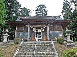
Yamatsumi Shrine, Mt. Toratori, Iitate Village
Article

07564 / いいたてむら

Fukushima Prefecture 相馬郡

Iitate Village

Wolf paintings fill a shrine's ceiling.

Yamatsumi Shrine, Mt. Toratori

Photo by Haruhiko Okumura (CC BY 2.0)

01 / White wolf

A tale survives at the foot of Mt. Toratoriyama:a white wolf led the way to the outlaws' hideout.

White wolf in Iitate Village
Photo by Bachstelze (CC BY-SA 3.0)

The prefecture's newsletter introduces a shrine to the mountain god that has continued since the Heian period. A tale remains that when an attempt was made to subdue outlaws who were causing trouble in Tohoku, a white wolf guided the way to where they hid. The village says the shrine stands on the southern slope, with a path to an inner shrine at the summit.

  • Mt. Toratoriyama, 705 m
  • Shrine on the southern slope
  • Inner shrine at the summit
  • One of the Fukushima 100 Mountains

02 / Well

A well whose water depth in the cold season,measured with a rod, foretells the harvest.

The well in Fukaya is 0.85 m across and 3.6 m deep. During the "kan" period of the 24 solar terms, its water depth is measured with a rod. The village says 2.25 m from the bottom means an average harvest and 2.3 m or more a good one, but there is no strict standard and it is left to individual judgment.

  • 0.85 m across, 3.6 m deep
  • Depth measured with a rod in the cold season
  • 2.25 m from the bottom: average harvest

03 / Rice-planting dance

The Yawaki rice-planting dancecombines the Seven Gods and a planting dance.

The village says a lively dance is offered at the Little New Year to pray for a good harvest. According to the village's digital archive, the Yawaki dance consists of the Seven Gods and a rice-planting dance. Locally the two are called simply the rice-planting dance. The prefecture's list includes the Iitate rice-planting dance as an important intangible folk cultural property.

  • Seven Gods and a planting dance
  • Offered at the Little New Year
  • Prefectural important intangible folk cultural property

Iitate Village from the sky

Now and 1974–78. Tap a photo to zoom in.

Wide (about 6 km across)

Close (about 1.5 km across)

Shot 1974–78

Source: Geospatial Information Authority of Japan (GSI) GSI Tiles(国土画像情報(第一期:1974〜1978年撮影))

Open in GSI Maps (1974–78)

Living here

68 minutes by bus from Fukushima Station.

  • about 1,000 people
  • Rural district town

There is no railway station in the village. The village tells visitors to take a Fukushima Kotsu bus from Fukushima Station. In the Fukushima Kotsu timetable (April 1, 2026 edition), the fastest daily bus takes 68 minutes from Fukushima Station East Exit to a stop in the village. The village belongs to Soma District.

People living here
1,318people
19952020

+3114.6% since 2015

7,586 → 1,318

Area
230.13km²

57.04km² of it habitable

2024

Households
627households

2.1 people per household

2020

Rent (average for rentals)
—
Healthcare
0 hospitals / 2 clinics

15.2 per 10,000 people

2023

Area230.13km²Habitable land57.04km² / 25%
Area and habitable land at the same scalee-Stat B1101 / B1103
Children waiting for childcare
—1 nurseries and similar
Home purchase subsidy
—
Average annual temperature
—

These 3 items are waiting on a nationwide data source. We do not fill them with estimates.

ACCESS

Where you can go from here.

Iitate Village in Japan37.679°N 140.735°E
TokyoOsakaIitate Village
飯舘村役場
飯舘村役場2008
  • to FukushimaLocal bus68min

Travel times follow 福島交通『バス時刻表 福島管内No.4』(2026年4月1日版。飯舘村公式『コミュニティバス・交通』→『公共交通機関のご案内』〈更新2026-03-25〉が貼る PDF https://www.vill.iitate.fukushima.jp/uploaded/attachment/17634.pdf の2枚目)の『福島=医大=川俣=飯舘=南相馬』。**上段が平日用、下段が土日祝用で、飯舘への便は6往復とも時刻が同じ**(凡例に『年末年始〈12/31〜1/3〉は日曜日・祝日の時刻で運行』)。**福島駅東口 → いいたて村までい館(町の外→村の向き)**:610→718・950→1058・1230→1338・1500→1608・1605→1713・1825→1933(6便すべて68分。平日・土日祝とも同じ)。逆向き(いいたて村までい館 → 福島駅東口):747→901・1102→1216・1317→1431・1447→1601・1647→1801・1842→1956(6便すべて74分。往復で6分違う)。運転日の注記(平日のみ・土日運休・特定日など)は無い。表の注記は『飯野〜福島間、医大〜福島間の乗降扱いは出来ません』だけ(飯野町・医大病院の停留所の乗降の話で、いいたて村までい館〜福島駅東口の乗車には関係しない)。運賃は福島駅東口→いいたて村までい館が1,100円 (checked 2026-10-28). They vary by time of day.

Shape

Borders 5 municipalities.

Territory of Iitate Village
Boundaries: National Land Numerical Information (Administrative Area Data), MLIT. Processed by Machigatari.Lakes: National Land Numerical Information (Lake Data), MLIT. Processed by Machigatari. Prepared with the approval of the Director-General of the Geospatial Information Authority of Japan, using its Digital Map 25000 (Spatial Data Framework) and Digital Map 25000 (Place Names and Public Facilities). (承認番号 平27情使、第585号)

Iitate Village isthis kind of town.

  1. 01Yamatsumi Shrine stands on the southern slope of Mt. Toratoriyama, and the Fukushima tourism association says more than 200 wolf paintings can be seen on the ceiling
  2. 02A tale remains that a white wolf led the way to where outlaws hid, at a shrine to the mountain god that has continued since the Heian period, the prefecture's newsletter says
  3. 03Fukaya's Sakumi well foretells the harvest from the depth of its water in the cold season, and the Yawaki rice-planting dance combines the Seven Gods and a planting dance

If something caught your eye, ask the town itself.