Fukushima Prefecture has 59 municipalities (13 cities, 31 towns, 15 villages). All of them have town stories to read.
Boundaries: National Land Numerical Information (Administrative Area Data), MLIT. Processed by Machigatari.Lakes: National Land Numerical Information (Lake Data), MLIT. Processed by Machigatari. Prepared with the approval of the Director-General of the Geospatial Information Authority of Japan, using its Digital Map 25000 (Spatial Data Framework) and Digital Map 25000 (Place Names and Public Facilities). (承認番号 平27情使、第585号)
Point at an interest to light up its towns on the map.
Point at a town to see it here. Click to open its page.
07201 / Kenpoku
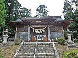
Fukushima City
ふくしまし
Said to be named for ten wisteria ropes.
Totsuna Bridge, steel arch
Population
282,693
5-year change
−3.9%
to Tokyo
78 min
Hot springsA river runs throughTraditional crafts十綱橋飯坂温泉
MountainsA river runs throughIt snowsCool summersPost town
Click to open Minamiaizu Town.
07402 / Aizu
Kitashiobara Village
きたしおばらむら
The village records over 300 alpine plants in a marsh.
Oguninuma Marsh plant community
Population
2,556
5-year change
−9.7%
to Kitakata
18 min
MountainsA lakeIt snowsPost townHot springs
Click to open Kitashiobara Village.
07405 / Aizu
Nishiaizu Town
にしあいづまち
A bridge that held a crossing ceremony in 1938.
Former bridge
Population
5,770
5-year change
−12.3%
MountainsA river runs throughPost town旧柴崎橋阿賀川
Click to open Nishiaizu Town.
07407 / Aizu
Bandai Town
ばんだいまち
Golden hall restored on excavated base.
Enichiji ruins, restored hall
Population
3,322
5-year change
−7.2%
MountainsNatural springs慧日寺跡慧日寺金堂龍ケ沢湧水
Click to open Bandai Town.
07408 / Aizu
Inawashiro Town
いなわしろまち
A hilltop house named for a Li Bai line.
Tenkyokaku
Population
13,552
5-year change
−9.9%
A lakeMountainsMountain climbingHot springs天鏡閣
Click to open Inawashiro Town.
07421 / Aizu
Aizubange Town
あいづばんげまち
Two tomb shapes stand side by side.
Kamegamori and Chinjumori Kofun
Population
15,068
5-year change
−7.6%
PlainsA river runs throughIt snowsMany shrines and temples亀ヶ森古墳
Click to open Aizubange Town.
07422 / Aizu
Yugawa Village
ゆがわむら
Flatland castle, 5 m above the riverbed.
Castle ruins, river terrace
Population
3,081
5-year change
−3.9%
A river runs throughFarming townRice countryNational TreasureIt snows
Click to open Yugawa Village.
07423 / Aizu
Yanaizu Town
やないづまち
A temple known across Aizu as Yanaizu's Kokuzo-sama.
A temple by the Tadami River
Population
3,081
5-year change
−12.9%
A river runs throughTemple gate townHot springs圓藏寺柳津虚空藏尊
Click to open Yanaizu Town.
07444 / Aizu
Mishima Town
みしままち
An arched iron bridge spans the river.
First Tadami River Bridge
Population
1,452
5-year change
−12.9%
A river runs throughMountainsIt snowsTraditional crafts第一只見川橋梁
Click to open Mishima Town.
07445 / Aizu
Kaneyama Town
かねやままち
Natural sparkling water wells up here.
Oshio natural carbonated spring
Population
1,862
5-year change
−14.9%
MountainsA river runs throughA lakeIt snowsNatural springs
Click to open Kaneyama Town.
07446 / Aizu
Showa Village
しょうわむら
Ramie for fine cloth takes three years.
Karamushi ramie production
Population
1,246
5-year change
−5.7%
MountainsIt snowsNatural springsTraditional craftsFarming town
Click to open Showa Village.
07447 / Aizu
Aizumisato Town
あいづみさとまち
Rock cut open for a three-story hall.
Sakudari Kannon Hall, kakezukuri
Population
19,014
5-year change
−9.1%
Many shrines and templesNational TreasureFamous festival左下り観音堂法用寺
Click to open Aizumisato Town.
07461 / Kennan
Nishigo Village
にしごうむら
A place name recorded as a shrine's.
The shrine behind a place name
Population
20,808
5-year change
+2.4%
to Tokyo
68 min
MountainsA river runs throughHighlandsMountain climbingHot springs
Click to open Nishigo Village.
07464 / Kennan
Izumizaki Village
いずみざきむら
Behind a door, a red-painted rider.
Izumizaki Yokoana, painted tomb
Population
6,213
5-year change
−4.3%
MountainsA river runs throughFarming town泉崎横穴装飾古墳
Click to open Izumizaki Village.
07465 / Kennan
Nakajima Village
なかじまむら
A Jizo said to sweat before upheaval.
Asekaki Jizo, the Sweating Jizo
Population
4,885
5-year change
−2.3%
A river runs throughHot springsFarming town汗かき地蔵四穂田古墳
Click to open Nakajima Village.
07466 / Kennan
Yabuki Town
やぶきまち
An early 7th-century round tomb remains.
Ogre's Hole Tumulus
Population
17,287
5-year change
−0.5%
PlainsFarming townA river runs through鬼穴古墳矢吹ヶ原
Click to open Yabuki Town.
07481 / Kennan
Tanagura Town
たなぐらまち
A tree thought spared as a shrine moved.
Tanagura Castle Ruins Zelkova
Population
13,343
5-year change
−6.7%
A river runs throughFarming townA castle棚倉城跡大ケヤキ
Click to open Tanagura Town.
07482 / Kennan
Yamatsuri Town
やまつりまち
Blooms were a farm calendar, it seems.
Old Edo higan cherry, natural monument
Population
5,392
5-year change
−9.4%
MountainsA river runs throughMountain climbingVacant house bank戸津辺のサクラ
Click to open Yamatsuri Town.
07483 / Kennan
Hanawa Town
はなわまち
Three conical roofs top this station.
Iwaki-Hanawa Station, cone roofs
Population
8,302
5-year change
−9.3%
MountainsA river runs throughAn art museum磐城塙駅水郡線
Click to open Hanawa Town.
07484 / Kennan
Samegawa Village
さめがわむら
A lion on a cloud kicks its legs up.
Kumano Shrine, flying lions
Population
3,049
5-year change
−14.8%
to Iwaki-Ishikawa
33 min
MountainsA river runs throughFarming town熊野神社飛翔獅子
Click to open Samegawa Village.
07501 / Kenchu
Ishikawa Town
いしかわまち
Elaborate gate, symbol of a privilege.
Suzuki family's yakui-mon gate
Population
14,644
5-year change
−7.8%
MountainsHot springsFruit growing鈴木家主屋及び門薬医門
Click to open Ishikawa Town.
07502 / Kenchu
Tamakawa Village
たまかわむら
A cut-stone chamber faces south-southeast.
Miyanomae Kofun, chamber at Kawabe
Population
6,392
5-year change
−5.7%
A river runs throughFruit growing宮ノ前古墳切石積横穴式石室東福寺舎利石塔
Click to open Tamakawa Village.
07503 / Kenchu
Hirata Village
ひらたむら
No peak blocks the view; it stands proudly alone here.
Mt. Yomogidadake
Population
5,826
5-year change
−10.4%
to Koriyama
53 min
MountainsMountain climbingCool summersHighlandsFarming town
Click to open Hirata Village.
07504 / Kenchu
Asakawa Town
あさかわまち
The town designates a stone coffin.
Kanshu-ji, samadhi coffin
Population
6,036
5-year change
−8.2%
MountainsFarming townRice country貫秀寺福貴作石
Click to open Asakawa Town.
07505 / Kenchu
Furudono Town
ふるどのまち
Look up at a cherry about 400 years old.
Large mountain cherry, Furudono
Population
4,825
5-year change
−10.2%
MountainsA river runs throughFamous festivalFarming town越代のサクラ
Click to open Furudono Town.
07521 / Kenchu
Miharu Town
みはるまち
A hilltop annex for noh chant practice.
Shiunkaku, Yoshida family annex
Population
17,018
5-year change
−7%
Castle townMountains紫雲閣旧吉田家住宅三春城跡
Click to open Miharu Town.
07522 / Kenchu
Ono Town
おのまち
Cedars flank the path like a couple.
Jiji Sugi and Baba Sugi cedars
Population
9,471
5-year change
−9.6%
MountainsA river runs throughMountain climbingHot springsCamping
Click to open Ono Town.
07541 / Soso
Hirono Town
ひろのまち
Drums and flutes seem to name the rite.
Shore purification rite, Tantan Peropero
Population
5,412
5-year change
+25.3%
to Tokyo
159 min
Ueno 152 min
By the seaMountainsA river runs through浜下り神事たんたんぺろぺろ
Click to open Hirono Town.
07542 / Soso
Naraha Town
ならはまち
Buried together some 2,000 years ago.
Tenjinbara, Yayoi group burials
Population
3,710
5-year change
+280.5%
MountainsA river runs throughBy the sea天神原遺跡木戸川
Click to open Naraha Town.
07543 / Soso
Tomioka Town
とみおかまち
Cherry trees that form a tunnel.
Yonomori avenue, cherry tunnel
Population
2,128
to Tokyo
173 min
Ueno 166 min
By the seaMountains夜の森桜並木桜のトンネル夜ノ森駅
Click to open Tomioka Town.
07544 / Soso
Kawauchi Village
かわうちむら
A summit pond, a natural monument.
Hebusu Pond, tree frog habitat
Population
2,044
5-year change
+1.1%
MountainsA river runs throughHighlands平伏沼モリアオガエル
Click to open Kawauchi Village.
07545 / Soso
Okuma Town
おおくままち
Lion-clad children danced at the shrine.
Kumagawa Shishimai Dance
Population
847
to Tokyo
181 min
Ueno 174 min
MountainsA river runs throughBy the seaPost townFruit growing
Click to open Okuma Town.
07546 / Soso
Futaba Town
ふたばまち
A red spiral ringed by riders and deer.
Kiyotosaku Yokoana, mural
Population
0
to Tokyo
186 min
Ueno 179 min
By the seaMountainsMild winters清戸迫横穴装飾古墳
Click to open Futaba Town.
07547 / Soso
Namie Town
なみえまち
A hall estimated moved from the castle.
Main hall, prefectural property
Population
1,923
to Tokyo
191 min
Ueno 184 min
By the seaA river runs throughTraditional crafts初発神社大堀相馬焼
Click to open Namie Town.
07548 / Soso
Katsurao Village
かつらおむら
Three shrines enshrined on the summit.
Mount Hiyama, Tennoyama
Population
420
5-year change
+2233.3%
to Funehiki
53 min
MountainsHighlandsMountain climbing日山天王山
Click to open Katsurao Village.
07561 / Soso
Shinchi Town
しんちまち
Every legend of its god involves horses.
Kobimine Shrine, horse guardian
Population
7,905
5-year change
−3.8%
MountainsBy the seaMountain climbing子眉嶺神社新地貝塚
Click to open Shinchi Town.
07564 / Soso
Iitate Village
いいたてむら
Wolf paintings fill a shrine's ceiling.
Yamatsumi Shrine, Mt. Toratori
Population
1,318
5-year change
+3114.6%
to Fukushima
68 min
MountainsA river runs throughMountain climbingCamping山津見神社
Click to open Iitate Village.
Lakes: National Land Numerical Information (Lake Data), MLIT. Processed by Machigatari. Prepared with the approval of the Director-General of the Geospatial Information Authority of Japan, using its Digital Map 25000 (Spatial Data Framework) and Digital Map 25000 (Place Names and Public Facilities). (承認番号 平27情使、第585号)
All municipalities
Name, pronunciation and type. A readable town links to its page.