Former bridge, Nishiaizu Town
Article

07405 / にしあいづまち

Fukushima Prefecture 耶麻郡

Nishiaizu Town

A bridge that held a crossing ceremony in 1938.

Former bridge

Photo by Ebiebi2 (CC BY-SA 4.0)

01 / Post station

In this post station, each house is set at an angle,built like the teeth of a saw.

The town newsletter's "Nishiaizu Stories" series describes one of the post stations in a district of the town as a row of houses each set at an angle, unlike the usual straight line along a road. Old inn names are still painted on the walls, and the newsletter calls it a "very rare row of houses."

  • Each house set at an angle
  • Old inn names painted on the walls
  • Town-designated site: a milestone

02 / Mountain deity

Visit for three years in a row, and the mountain deityis said to grant one wish in a lifetime.

Mountain deity in Nishiaizu Town
Photo by tail_furry (CC BY-SA 3.0)

The town newsletter says the shrine enshrines Oyamazumi no Mikoto and his daughters Iwanagahime and Konohanasakuyahime, and that the whole mountain is sacred ground. Past cedar trees and 202 stone steps from a hamlet's worship hall stands the main shrine. The town says its grand festival runs for a month each June.

  • Three deities enshrined
  • Cedar avenue and 202 stone steps
  • Grand festival for a month each June

03 / Kannon hall

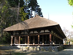
A thatched, three-bay hall with a hip-and-gable roofmoved to its present site in a 1970 dismantling repair.

The town newsletter describes the Kannon hall of a temple in the town as a three-bay hall of the Northern and Southern Courts period with a hip-and-gable roof, cypress frame and thatch, said to have been built in 1336. It stood in the temple grounds until it was moved to its present site during the 1970 dismantling repair. It is an Important Cultural Property.

  • Nationally designated Important Cultural Property (building)
  • Three bays, hip-and-gable roof, cypress, thatch
  • Moved in the 1970 dismantling repair

Nishiaizu Town from the sky

Now and 1974–78. Tap a photo to zoom in.

Wide (about 6 km across)

Close (about 1.5 km across)

Now (shot July–September 2022)Shot 1974–78

Source: Geospatial Information Authority of Japan (GSI) GSI Tiles(全国最新写真(シームレス)/国土画像情報(第一期:1974〜1978年撮影))

Open in GSI Maps (now)Open in GSI Maps (1974–78)

Living here

Four stations on the Banetsu West Line.

  • about 6,000 people
  • Rural district town

The town has four JR Banetsu West Line stations: Nozawa, Onobori, Kami-Nojiri and Tokusawa. The town's access map gives 50 minutes on the Banetsu West Line from Aizuwakamatsu Station to Nozawa Station. The town office is in Nozawa, and the town reports a population of 5,137 as of October 1, 2026.

People living here
5,770people
19952020

−12.3% since 2015

9,845 → 5,770

Area
298.18km²

48.12km² of it habitable

2024

Households
2,352households

2.5 people per household

2020

Rent (average for rentals)
—
Healthcare
0 hospitals / 8 clinics

13.9 per 10,000 people

2023

Area298.18km²Habitable land48.12km² / 16%
Area and habitable land at the same scalee-Stat B1101 / B1103
Children waiting for childcare
—1 nurseries and similar
Home purchase subsidy
—
Average annual temperature
—

These 3 items are waiting on a nationwide data source. We do not fill them with estimates.

Shape

Borders 5 municipalities across 1 prefectures.

Nishiaizu Town in Japan37.587°N 139.649°E
TokyoOsakaNishiaizu Town
Territory of Nishiaizu Town
Boundaries: National Land Numerical Information (Administrative Area Data), MLIT. Processed by Machigatari.Lakes: National Land Numerical Information (Lake Data), MLIT. Processed by Machigatari. Prepared with the approval of the Director-General of the Geospatial Information Authority of Japan, using its Digital Map 25000 (Spatial Data Framework) and Digital Map 25000 (Place Names and Public Facilities). (承認番号 平27情使、第585号)

North to south

34.0km

Niigata Prefecture
Aga Town

Travel times per leg are not published by the municipality, so they are not shown.

Nishiaizu Town isthis kind of town.

  1. 01A former bridge stood in a community that ran a ferry landing, and the town newsletter says a crossing ceremony was held on July 31, 1938 with the prefectural governor
  2. 02One of the post stations in a district of the town is described by the town newsletter as a row where each house is set at an angle like the teeth of a saw
  3. 03The mountain shrine is said to grant one wish in a lifetime to those who visit three years running, and a temple's Kannon hall is a thatched three-bay hall moved in 1970

See the town as it is now.

Source: Wikidata (P2002, P2003, P2013, P2397)

If something caught your eye, ask the town itself.

From this town's themes