Tengu fire walk, Kotohira Shrine, Furubira Town
Article

01406 / ふるびらちょう

Hokkaido 古平郡

Furubira Town

A tengu walks through fire at night.

Tengu fire walk, Kotohira Shrine

Photo by 禁樹なずな (CC BY-SA 4.0)

01 / Furubira River

A red cliff on the river is saidto have named the place.

Furubira River in Furubira Town
Photo by 禁樹なずな (CC BY-SA 4.0)

According to the town, Furubira is the name of the river now called the Furubira River, once known as Porobetsu. A red cliff stood on this river, and calling it Furepira ("red cliff") is said to have become the name of the place.

  • Furepira = "red cliff"
  • The river was once said to be called Porobetsu
  • Flat land lies along the Furubira and Maruyama rivers

02 / Furubira Basho

Under Matsumae rule, Furubira Bashowas opened as a herring ground.

Furubira Basho in Furubira Town
Photo by Miyuki Meinaka (CC BY-SA 4.0)

In the Edo period, under the Matsumae domain, the area was called Furubira and Furubira Basho and was opened up as a herring fishing ground, the town records. It is still a fishing town, landing shrimp, octopus, Atka mackerel and flounder. In 2020 it had 153 people working in fishing.

  • Edo period, under Matsumae rule
  • Town charter: "built on herring"
  • 153 fishing workers (2020)

03 / Setakamui Rock

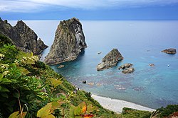
A rock like a howling dogbears the name "dog god."

The town's municipal profile introduces Setakamui Rock as a strange rock whose Ainu name means "dog god." Because it resembles a dog howling, a legend remains that a dog waiting for an owner who never returned from fishing turned into the rock.

  • Ainu name meaning "dog god"
  • Resembles a howling dog
  • A legend of a dog turned to rock

Furubira Town from the sky

Now and 1974–78. Tap a photo to zoom in.

Wide (about 6 km across)

Close (about 1.5 km across)

Now (shot May–September 2025)Shot 1974–78

Source: Geospatial Information Authority of Japan (GSI) GSI Tiles(全国最新写真(シームレス)/国土画像情報(第一期:1974〜1978年撮影))

Open in GSI Maps (now)Open in GSI Maps (1974–78)

Living here

No station; 32 minutes by bus from Yoichi Station.

  • about 3,000 people
  • Rural district town

There is no railway station in the town, and no railway runs between Yoichi and Furubira. On the Hokkaido Chuo Bus Shakotan Line (summer timetable revised April 1, 2026), the trip from Yoichi Station stop to Furubira Hamamachi takes 32 minutes on daily services.

People living here
2,745people
19952020

−13.9% since 2015

4,654 → 2,745

Area
188.36km²

26.74km² of it habitable

2024

Households
1,282households

2.1 people per household

2020

Rent (average for rentals)
—
Healthcare
0 hospitals / 1 clinic

3.6 per 10,000 people

2023

Area188.36km²Habitable land26.74km² / 14%
Area and habitable land at the same scalee-Stat B1101 / B1103
Children waiting for childcare
—1 nurseries and similar
Home purchase subsidy
—
Average annual temperature
—

These 3 items are waiting on a nationwide data source. We do not fill them with estimates.

ACCESS

Where you can go from here.

Furubira Town in Japan43.265°N 140.639°E
TokyoOsakaFurubira Town
Furubira Town Office
古平町役場2025
  • to YoichiLocal bus32min

Travel times follow 北海道中央バス『郊外線(余市)2026夏ダイヤ時刻表』(https://www.chuo-bus.co.jp/city_route/pdf/otaru_G.pdf・2026年4月1日改正・PDF 作成 2026-03-10)の積丹線(系統番号⑳・小樽〜余市〜古平〜美国)。小樽駅前→古平浜町は9:00→10:06・10:00→11:06・12:00→13:06・14:00(平日のみ)→15:06・15:00→16:06・16:30→17:36・17:30→18:36・19:10(土日祝のみ)→20:16・19:30(平日のみ)→20:36 で、どの便も66分。余市駅前→古平浜町は9:34→10:06 など毎便32分。逆向き(古平浜町→小樽駅前)は6:15→7:23・7:35→8:43・10:11→11:19・13:31→14:39・14:51→15:59・16:41→17:49 の68分(17:41→18:51 の70分は平日のみ)、古平浜町→余市駅前は30〜31分 (checked 2026-10-29). They vary by time of day.

Shape

Borders 6 municipalities.

Territory of Furubira Town
Boundaries: National Land Numerical Information (Administrative Area Data), MLIT. Processed by Machigatari.Lakes: National Land Numerical Information (Lake Data), MLIT. Processed by Machigatari. Prepared with the approval of the Director-General of the Geospatial Information Authority of Japan, using its Digital Map 25000 (Spatial Data Framework) and Digital Map 25000 (Place Names and Public Facilities). (承認番号 平27情使、第585号)

Furubira Town isthis kind of town.

  1. 01At the Kotohira Shrine festival, a figure in vermilion dress and a tengu mask leads the way through town and crosses fire at night. The Kotohira Shrine festival mikoshi procession is a Hokkaido-designated intangible folk cultural property
  2. 02The town name is said to come from a red cliff on the river, called Furepira, that became the name of the place, and Furubira Basho was opened as a herring ground. Setakamui Rock carries a legend of a dog turned to stone
  3. 03The town has no railway station; a Hokkaido Chuo Bus runs from Yoichi Station to Furubira Hamamachi

If something caught your eye, ask the town itself.