Tsurunuma Glasswort Colony, Yubetsu Town
Article

01559 / ゆうべつちょう

Hokkaido 紋別郡

Yubetsu Town

Past a bridge, plants turn red in fall.

Tsurunuma Glasswort Colony

Photo by MaedaAkihiko (CC BY-SA 4.0)

01 / Former Kerochi Station Park

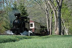
A former station is kept as it was,with 1923 rails, some made in Belgium.

Former Kerochi Station Park in Yubetsu Town
Photo by 221.20 (Public domain)

This park along National Route 238 keeps the former Kerochi Station of the old railway line as it was. The station building, the platform and rails made in 1923 (some in Belgium) remain, and a C58 steam locomotive is on display. A 300 m boardwalk leads toward Lake Saroma.

  • Developed in fiscal 1988; opened June 1989
  • Rails made in 1923 (some Belgian-made)
  • C58 steam locomotive on display

02 / Kamiyubetsu Tulip Park

About 200 varieties and 700,000 tulipsbloom in a 12.5-hectare park.

Kamiyubetsu Tulip Park in Yubetsu Town
Photo by ほくなん (Public domain)

The town describes a site of 12.5 hectares in total, with 7 hectares planted, where about 700,000 tulips of about 200 varieties bloom. The tulip fair runs from May 1 to May 31 every year, and the flowers are usually at their best from mid to late May.

  • About 200 varieties, 700,000 tulips
  • 12.5 ha total, 7 ha planted
  • Fair held May 1 to 31 each year

03 / Shibunotsunai Pit Dwellings

In a pasture grazed May to October,pit-dwelling hollows show on the ground.

This is a Hokkaido-designated historic site. More than half of the pit dwelling remains are thought to date from the Satsumon culture, about 1,000 years ago. The hollows remain on the ground surface, and the site is used as public pasture, where cattle graze from May to October.

  • Hokkaido-designated historic site (1967)
  • Over half thought to be about 1,000 years old (Satsumon culture)
  • Public pasture; cattle graze May to October

Yubetsu Town from the sky

Now and 1974–78. Tap a photo to zoom in.

Wide (about 6 km across)

Close (about 1.5 km across)

Now (shot July–August 2024)Shot 1974–78

Source: Geospatial Information Authority of Japan (GSI) GSI Tiles(全国最新写真(シームレス)/国土画像情報(第一期:1974〜1978年撮影))

Open in GSI Maps (now)Open in GSI Maps (1974–78)

Living here

No station; 16 minutes by bus from Engaru.

  • about 8,000 people
  • Rural district town

There is no railway station in the town; the nearest active JR station is Engaru on the Sekihoku Main Line. On the Kitami Bus Yubetsu line (timetable revised April 1, 2026), the fastest daily service runs from Engaru to the Kamiyubetsu stop in 16 minutes, with no change.

People living here
8,270people
2010

−10.4% since 2015

10,041 → 8,270

Area
505.79km²

186.26km² of it habitable

2024

Households
3,692households

2.2 people per household

2020

Rent (average for rentals)
—
Healthcare
1 hospital / 3 clinics

4.8 per 10,000 people

2023

Area505.79km²Habitable land186.26km² / 37%
Area and habitable land at the same scalee-Stat B1101 / B1103

Population from 2010 onward (municipal boundary changed).2009-10-05 に新設合併(上湧別町)。2010年調査から市域が変わっている。

Children waiting for childcare
—4 nurseries and similar
Home purchase subsidy
—
Average annual temperature
—

These 3 items are waiting on a nationwide data source. We do not fill them with estimates.

ACCESS

Where you can go from here.

Yubetsu Town in Japan44.151°N 143.573°E
TokyoOsakaYubetsu Town
Yubetsu Town Office (Kamiyubetsu Building)
湧別町役場 上湧別庁舎2013
  • to EngaruLocal bus16min

Travel times follow 北海道北見バス『バス運行時刻表 郊外線②』令和8年(2026年)4月1日改定(https://www.h-kitamibus.co.jp/wp-content/themes/h-kitamibus/img/download/suburbroute2-timetable-202604.pdf)の『湧別・湧紋線』(北見バス:遠軽~湧別)。**遠軽 → 上湧別**:6:38 発 → 上湧別 6:54 着(16分)。7:20→7:37・8:00→8:17・10:00→10:17・10:57→11:14・11:45→12:02・12:35→12:52・13:30→13:47・15:20→15:37 は17分。凡例は『青枠は土曜・日曜・祝日運休』で、6:25・9:15・14:30・20:00 の便(青枠)は数えない(PDF を画像にして色を確かめた)。**逆向き(上湧別 → 遠軽)**:7:42→8:02・11:07→11:27・12:52→13:12・14:37→14:57・16:57→17:17 は20分、12:04→12:25 は21分(10:22 発と15:39 発は青枠で数えない)。 (checked 2026-10-29). They vary by time of day.

Shape

Borders 4 municipalities.

Territory of Yubetsu Town
Boundaries: National Land Numerical Information (Administrative Area Data), MLIT. Processed by Machigatari.Lakes: National Land Numerical Information (Lake Data), MLIT. Processed by Machigatari. Prepared with the approval of the Director-General of the Geospatial Information Authority of Japan, using its Digital Map 25000 (Spatial Data Framework) and Digital Map 25000 (Place Names and Public Facilities). (承認番号 平27情使、第585号)

Yubetsu Town isthis kind of town.

  1. 01The town's Tsurunuma holds a Hokkaido-designated natural monument, the glasswort colony on the shore of Lake Saroma. It grows over about 20,000 m² beyond a small suspension bridge and, the town says, turns bright red every year in mid-September
  2. 02Kerochi Railway Park keeps the former Kerochi Station of the old railway line, with rails made in 1923. The town also has Kamiyubetsu Tulip Park, with about 700,000 tulips of about 200 varieties, and the Hokkaido-designated Shibunotsunai pit dwelling site
  3. 03The town has no railway station; a Kitami Bus runs from Engaru to the Kamiyubetsu stop

If something caught your eye, ask the town itself.