Mozume Kurumazuka Kofun, sekkan.jpg
Article

26208 / むこうし

Kyoto Prefecture

Muko City

Lid bumps are called rope-hanging knobs.

Mozume Kurumazuka Kofun, coffin

Photo by Saigen Jiro (CC0)

01 / Folk dance

Thirteen dances,with only a drum and wooden clappers.

Sekitouji.JPG
Photo by KishujiRapid (CC BY-SA 3.0)

Offered each year at Sekito-ji Temple in Kaide on 3 May, the Flower Festival. The dancers hold fans or sedge hats, and the daimoku chant comes at the end of every piece. A preservation society was formed in the Showa 40s (1965-74), and the dance is a Kyoto Prefecture Intangible Folk Cultural Property.

  • 13 dances
  • 3 May, offered at Sekito-ji Temple
  • Prefectural Intangible Folk Cultural Property
02 / Shrine

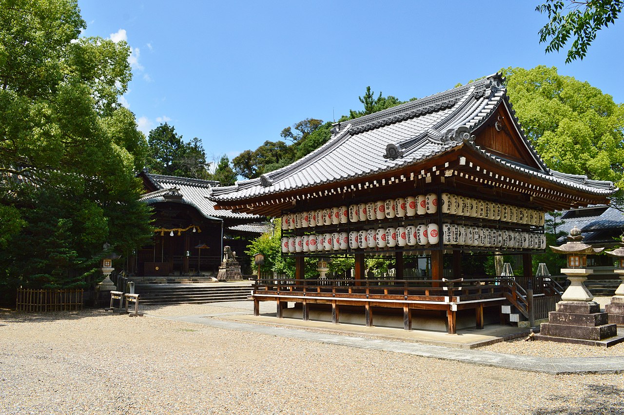
Five ridge plaques on the main hallrecord the names of people from seven surrounding villages.

Muko-jinja, shaden.jpg
Photo by Saigen Jiro (CC0)

The main hall, a three-bay nagare-zukuri building, was begun in Oei 25 (1418) and raised in Oei 29 (1422). It is an Important Cultural Property. The plaques show it was the villages' shared guardian shrine. The hall sits inside a protective housing, and the 13 auxiliary buildings around it were registered as national Registered Tangible Cultural Properties in 2015.

  • Raised in 1422
  • 5 ridge plaques
  • 13 auxiliary buildings registered in 2015

03 / Palace site

The name of a building over 1,200 years oldstill marks a place in Kaide.

Daigokuden nt 1.jpg
Photo by Muscla3pin (CC BY-SA 4.0)

The Daigokuden site became a National Historic Site in 1964 and is now Daigokuden Park. Old Ueda House stands on the site of the palace's inner-enclosure walled corridor. It was moved about 190 m from the east in 1942, was registered as a national Registered Tangible Cultural Property in 2019, and the corridor's line is marked on the paving.

  • National Historic Site, 1964
  • Moved about 190 m in 1942
  • Registered in 2019

Living here

7 minutes from Kyoto, 34 from Osaka by JR Rapid.

  • about 60,000 people

To JR Mukomachi Station it is 7 minutes from Kyoto on a local train of the Tokaido Main Line, and 34 minutes from Osaka on the JR Rapid. The nearest station to City Hall is Hankyu's Higashi-Muko Station on the Kyoto Line, about a 15-minute walk.

People living here
56,859people
19952020

+6.5% since 2015

53,290 → 56,859

Area
7.72km²

6.82km² of it habitable

2024

Households
23,525households

2.4 people per household

2020

Rent (average for rentals)
60,612yen

National average 60,630 yen

2023

Healthcare
1 hospital / 48 clinics

8.6 per 10,000 people

2023

Area7.72km²Habitable land6.82km² / 88%
Area and habitable land at the same scalee-Stat B1101 / B1103
Children waiting for childcare
—9 nurseries and similar
Home purchase subsidy
—
Average annual temperature
—

These 3 items are waiting on a nationwide data source. We do not fill them with estimates.

ACCESS

Where you can go from here.

Muko City in Japan34.949°N 135.698°E
TokyoMuko City
Higashi-Muko Station
東向日駅2025
  • to KyotoJR7min
  • to OsakaJR Rapid34min

Travel times follow JR西日本『JRおでかけネット』区間時刻表(ページの日付 2026-10-08・木)。line-timetable/2234(琵琶湖線・JR京都線・JR神戸線 米原~大阪~姫路 下り)で京都『発』→向日町『発』、line-timetable/2235(同 上り)で大阪『発』→向日町『発』を、同じ列車の列で数えた。向日町駅の行は『発』だけで『着』の行が無い(停車は1分前後)ので、『発』どうしの差を採った。 (checked 2026-10-08). They vary by time of day.

Shape

Borders 2 municipalities.

Territory of Muko City
Boundaries: National Land Numerical Information (N03)Lakes: National Land Numerical Information (Lake Data), MLIT. Processed by Machigatari. Prepared with the approval of the Director-General of the Geospatial Information Authority of Japan, using its Digital Map 25000 (Spatial Data Framework) and Digital Map 25000 (Place Names and Public Facilities). (承認番号 平27情使、第585号)

North to south

4.5km

京都市, 長岡京市

Muko City isthis kind of town.

  1. 01Mozume Kurumazuka Kofun is a keyhole-shaped mound of the mid-6th century, one of the National Historic Site Otokuni Kofun Group. The house-shaped stone coffin of assembled slabs in its chamber has lid and base projections called rope-hanging knobs (nawakake-tokki), and parts of a chest-shaped stone coffin were reused in the chamber stones
  2. 02Mozume Castle Site, a square manor with moat and earthen banks, became a National Historic Site in 2024, and Terado Otsuka Kofun is a keyhole-shaped mound of the early Kofun period along the Take no Michi path
  3. 03The city records that Yamamoto Shinjiro found a single plant of the rice variety Asahi in 1908, and in 1954 Nakayama Shuichi carried out the excavation that fixed the location of Nagaokakyo. Kyoto is 7 minutes away by JR

See the town as it is now.

Source: Wikidata (P2002, P2003, P2013, P2397)

If something caught your eye, ask the town itself.