Cerasite owned by Sakura Tenmangu Shrine D.jpg
Article

26206 / かめおかし

Kyoto Prefecture

Kameoka City

Cherry blossoms bloom inside the stone.

Cerasite, Hiedano pseudomorph

Photo by さかおり (CC BY-SA 4.0)

01 / Festival

A stage that joins the festival procession,with 35 cm puppets worked by one person.

A joint festival of Hiedano, Goryo, Kawakuma and Wakamiya shrines, held every year on 14 August. On a mobile stage called a dai-toro, puppets about 35 cm tall perform to gidayu-bushi music. One person works each puppet.

  • Important Intangible Folk Cultural Property, 2009
  • Joint festival of 4 shrines
  • Puppets about 35 cm

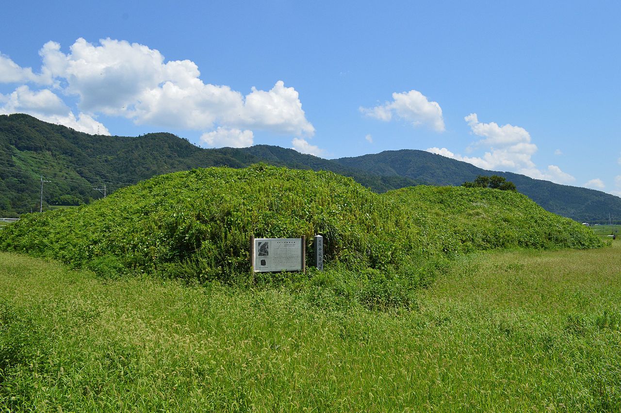
02 / Tomb

A keyhole tomb thought to date from the early 6th century.One theory says a king named in the Nihon Shoki lies here.

Chitose Kurumazuka Kofun zenkei.JPG
Photo by Saigen Jiro (CC0)

A keyhole-shaped mound in Chitose, about 80 m long. A study describes three tiers and a double moat. One theory identifies the occupant as a king named in the Nihon Shoki. It was designated a National Historic Site in 1982.

  • National Historic Site, 1982
  • Thought to date from the early 6th century
  • Mound about 80 m long

03 / Fish

When an irrigation rubber dam rises,a spawning ground for the ayumodoki appears.

Leptobotia curta Miyajima.jpg
Photo by Totti (CC BY-SA 4.0)

This loach spawns only in temporary waters created by floods. In Kameoka, when agricultural rubber dams are raised, a floodplain-like environment is created artificially, and the spawning and breeding habitat has been protected. The photo shows a fish kept in an aquarium.

  • National Natural Monument, 1977
  • City fish since 2017
  • According to the city, found only in Okayama Prefecture and Kameoka

Living here

17 minutes from Kyoto Station by limited express.

  • about 90,000 people

From Kyoto Station to JR Kameoka Station takes 17 minutes at the fastest on the Sagano Line limited express, or 19 minutes by rapid service. City Hall is about a 15-minute walk from Kameoka Station, or about 5 minutes by community bus.

People living here
86,174people
19952020

−3.7% since 2015

92,398 → 86,174

Area
224.8km²

72.01km² of it habitable

2024

Households
34,431households

2.5 people per household

2020

Rent (average for rentals)
49,180yen

National average 60,630 yen

2023

Healthcare
4 hospitals / 65 clinics

8.0 per 10,000 people

2023

Area224.8km²Habitable land72.01km² / 32%
Area and habitable land at the same scalee-Stat B1101 / B1103
Children waiting for childcare
—15 nurseries and similar
Home purchase subsidy
—
Average annual temperature
—

These 3 items are waiting on a nationwide data source. We do not fill them with estimates.

ACCESS

Where you can go from here.

Kameoka City in Japan35.014°N 135.573°E
TokyoKameoka City
Kameoka Station
亀岡駅2015
  • to KyotoJR limited express17min

Travel times follow JR西日本『JRおでかけネット』の駅時刻表(timetable.jr-odekake.net。『JR時刻表』2026年10月号に基づく)。京都駅の嵯峨野線(亀岡・園部・福知山方面)の駅時刻表(station-timetable/2784055001。2026-10-09金・10-10土・10-11日の3日分)に出る145本のうち、京都『発』・亀岡『着』が同じ列車の列に出る134本について、列車ごとの時刻表ページ(train-timetable/<列車ID>)の『運転日』欄と京都発・亀岡着の時刻を読んだ。『毎日運転』と書かれた列車を毎日の定期便として数えた (checked 2026-10-08). They vary by time of day.

Shape

Borders 6 municipalities across 1 prefectures.

Territory of Kameoka City
Boundaries: National Land Numerical Information (N03)Lakes: National Land Numerical Information (Lake Data), MLIT. Processed by Machigatari. Prepared with the approval of the Director-General of the Geospatial Information Authority of Japan, using its Digital Map 25000 (Spatial Data Framework) and Digital Map 25000 (Place Names and Public Facilities). (承認番号 平27情使、第585号)

North to south

20.6km

Kyoto Prefecture
南丹市, 京都市
Osaka Prefecture
能勢町, 高槻市, 茨木市, 豊能町

Kameoka City isthis kind of town.

  1. 01The cherry stone (cerasite) of Kakibana in Hiedano is a mass formed when cordierite altered; its cross-section shows a six-sided flower pattern, which gives it its name. It is a National Natural Monument and the city's designated stone
  2. 02The Saeki Toro festival is a nationally designated Important Intangible Folk Cultural Property, Chitose Kurumazuka is a National Historic Site, and the ayumodoki is the city fish and a National Natural Monument. The city's regional plan says Uketa Shrine's name comes from the god who opened the Hozu River in the age of the gods and "received" a hoe
  3. 03A city in the Kameoka basin of old Tamba Province, 17 minutes at the fastest from Kyoto Station by limited express on the Sagano Line

See the town as it is now.

Source: Wikidata (P2002, P2003, P2013, P2397)

If something caught your eye, ask the town itself.