旧和中散本舗機械.jpg
Article

25208 / りっとうし

Shiga Prefecture

Ritto City

A wooden gear turned the millstone.

Treadwheel mill, Wachusanhompo

Photo by Ohmishonin (CC0)

01 / Komasaka rock-carved Buddha

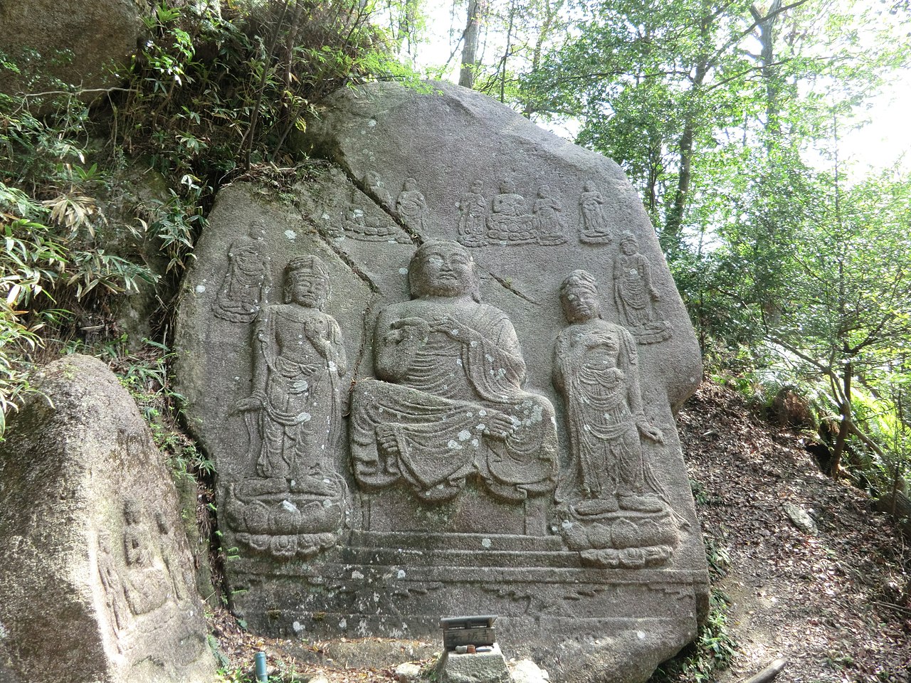
On the north face of a slightly tiltedgranite rock, an Amida triad is carved in half relief.
Komasaka Magaibutsu-Buddha figure carved on a rock face in Ritto city.jpg
Photo by Motokoka (CC BY-SA 4.0)

On a small hill south of the old Komasaka-dera Temple site stands a granite rock about 21 shaku high and 15 shaku wide. On its north face an Amida triad and a kebutsu (manifested Buddha) are carved in half relief: the central seated figure is about 9 shaku high, and the standing bodhisattvas on either side about 7.7 shaku. The Agency for Cultural Affairs describes it as a well-known rock-carved Buddha of the Kinki region.

  • Granite about 21 shaku high, 15 shaku wide
  • Central seated figure about 9 shaku
  • National Historic Site, 1944

02 / Kozue Festival

Children's flower-hat dances are said to carry ona plague-warding music from Muromachi Kyoto.

Otsuki-taisha honden.JPG
Photo by Saigen Jiro (CC0)

The grand festival of Otsuki Shrine is held on May 5. According to the city newsletter, children in splendid costume dance before the main hall and at the processional rest site, playing drums and hand gongs, while chanters sing distinctive sacred songs. Five villages take charge in turn, in the order of the zodiac; one of them, Yamadera, is in Kusatsu.

  • Grand festival on May 5
  • 2020: National Important Intangible Folk Cultural Property
  • 2022: UNESCO intangible cultural heritage

03 / Sumo festival

The tale goes that a water disputewas settled by children's sumo.

Daiho Shrine records that the festival goes back to a tale in which a dispute over water rights between Kitanakajii in Ritto and two villages in Moriyama was settled peacefully by children's sumo. In the ritual bouts, children chosen from the two sides wrestle three rounds; in the third, the referee calls "matta" (wait), and the result is held over until the next year. The shrine lists it among its events in October.

  • Three-round match
  • Referee calls "matta" in the third round
  • Result held over to next year

Living here

Kyoto in 27 minutes, Osaka in 71, by rapid train.

  • about 70,000 people
  • 90 min to a city centre

This city in the southwest of Shiga has two stations: Ritto Station on the Biwako Line and Tehara Station on the Kusatsu Line. JR rapid trains to Kyoto and Osaka leave from Ritto Station. The gateway is Tehara Station, the first station the city lists for reaching the city hall, about a 10-minute walk away.

People living here
68,820people
20052020

+3.1% since 2015

59,869 → 68,820

Area
52.69km²

29.58km² of it habitable

2024

Households
26,688households

2.6 people per household

2020

Rent (average for rentals)
56,465yen

National average 60,630 yen

2023

Healthcare
1 hospital / 58 clinics

8.6 per 10,000 people

2023

Area52.69km²Habitable land29.58km² / 56%
Area and habitable land at the same scalee-Stat B1101 / B1103
Children waiting for childcare
—13 nurseries and similar
Home purchase subsidy
—
Average annual temperature
—

These 3 items are waiting on a nationwide data source. We do not fill them with estimates.

ACCESS

Where you can go from here.

Ritto City in Japan35.022°N 135.998°E
TokyoRitto City
Tehara Station
手原駅2020
  • to KyotoJR Rapid27min
  • to OsakaJR Rapid71min

Travel times follow JR西日本『JRおでかけネット』区間時刻表(琵琶湖線・JR京都線・JR神戸線・山陽・東海道本線 姫路〜大阪〜米原 上り。https://timetable.jr-odekake.net/line-timetable/2235。ページの日付は 2026-10-07〈水曜〉と 2026-10-10〈土曜〉)の『京都 発』『大阪 発』と『栗東 発』(栗東は着時刻の行が無く発時刻だけの表)が同じ列車の列にあるかで、乗り換えなしで着く列車を数えた。2026-10-07:京都→栗東は74本(快速69・普通5)、大阪→栗東は69本(すべて快速)。運転日注意欄に印の無い(毎日運転の)便だけに絞ると、京都→栗東は7本で最速27分(普通900M 5:32→5:59・快速772T 14:37→15:04・快速784T 16:07→16:34ほか。27〜28分)、大阪→栗東は5本ですべて快速、最速71分(772T 13:53→15:04・784T 15:23→16:34・788T 15:53→17:05。71〜73分)。印のある便(平日の『平』・土休日の『土休』『◆』)まで含めると最速は京都26分(平日の快速5730T 9:54→10:20ほか)・大阪62分(平日の快速700M 5:54→6:56)で、平日朝の一部の大阪直通が60分台。**県の移住サイト『滋賀ぐらし』の栗東市のページは『京都まで約30分、大阪まで約60分』と書く**(起点の駅は書かれていない。県の値は最速の丸めとみられる) (checked 2026-10-07). They vary by time of day.

Shape

Borders 6 municipalities.

Territory of Ritto City
Boundaries: National Land Numerical Information (N03)Lakes: National Land Numerical Information (Lake Data), MLIT. Processed by Machigatari. Prepared with the approval of the Director-General of the Geospatial Information Authority of Japan, using its Digital Map 25000 (Spatial Data Framework) and Digital Map 25000 (Place Names and Public Facilities). (承認番号 平27情使、第585号)

North to south

12.3km

大津市, 草津市, 湖南市, 守山市, 甲賀市, 野洲市

Ritto City isthis kind of town.

  1. 01The treadwheel mill of the former Wachusanhompo was installed in 1831: two people walk inside a large wooden wheel, and wooden gears pass its force to a millstone that grinds herbs. The house is a National Historic Site, Important Cultural Property and Place of Scenic Beauty, and the mill was certified as Mechanical Engineering Heritage in 2023
  2. 02In the Konze mountains, at the site of the old Komasaka-dera Temple, the Komasaka rock-carved Buddha shows an Amida triad in half relief on granite. At Kusabira Shrine in Nakazawa, mushrooms are said to have sprung up overnight in a time of famine and saved the people
  3. 03The Kozue Festival of Otsuki Shrine, according to the city newsletter, keeps alive a plague-warding music that was popular in Muromachi-period Kyoto, danced by children in flower hats; with Kusatsu's Sanyare dances it is a National Important Intangible Folk Cultural Property and UNESCO intangible heritage. Daiho Shrine has a sumo festival based on a tale of children's sumo settling a water dispute

If something caught your eye, ask the town itself.