Danpusan-kofun 01.JPG
Article

23100 / なごやし

Aichi Prefecture

Nagoya City

Once said to be Miyazuhime's tomb; now thought the Owari clan's.

Danpusan Kofun

Photo by Saigen Jiro (CC0)

01 / Modern architecture

Stained glass of scales and the sunstill tells of the former court.

Nagoya city archives (Aichi) VLux5 hdsr 19.jpg
Photo by Hyppolyte de Saint-Rambert (CC BY 4.0)

The Nagoya City Archives building is the former Nagoya Court of Appeals, District Court and Summary Court building, built in Taisho 11 (1922). The stained glass at the front and on the ceiling of the central staircase hall shows scales and the sun, motifs for a fair trial, the city writes. The marble of the railings is said to be a rare domestic stone that can no longer be obtained.

  • Built 1922 (Taisho 11)
  • 1984: Important Cultural Property
  • Front: scales; ceiling: sun (city)

02 / Craft

A year before Nagoya Castle was builtis inscribed on four Gojo Bridge giboshi.

Gojo-bashi Bridge over Hori-kawa River, Nagoya 2014.jpg
Photo by Tomio344456 (CC BY-SA 4.0)

Six giboshi (bridge-post finials) once stood on Gojo Bridge, and four of them bear an inscription dated Keicho 7 (1602), before Nagoya Castle was built. They originally belonged to a bridge over the Gojo River south of Kiyosu Castle, and the city writes that they bear witness to Kiyosu-goshi, the move of the whole castle town to Nagoya. They were designated by the city in 2025.

  • Inscribed Keicho 7 (1602) on four giboshi
  • Apr 22, 2025: city-designated tangible cultural property (craft)
  • Made by the second Tarozaemon of the Mizuno family (city)

03 / Townscape

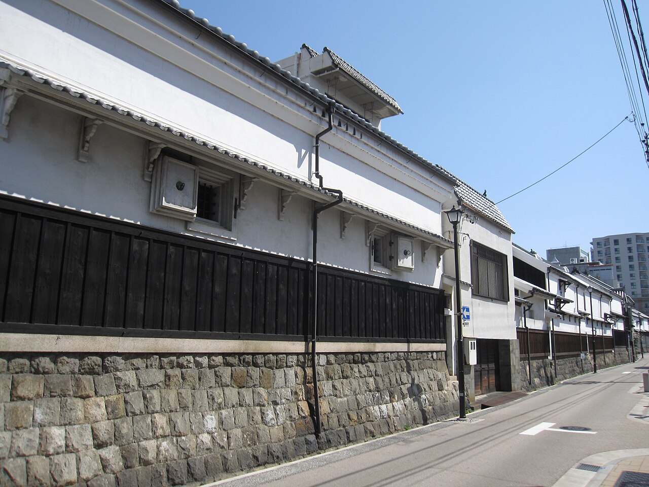
Black roof tiles and white plaster wallsline up above a stone wall.

Shikemichi Nagoya (1).JPG
Photo by Gryffindor (CC BY-SA 3.0)

Along Shikemichi, a stone wall about 1 m high was built on the east side of the street, and many storehouses still stand on top of it. The city calls the continuous black tiles, white plaster walls and stone wall the district's representative scenery. The area grew as a merchant quarter that used boat transport on the Hori River.

  • Stone wall about 1 m high (city)
  • June 1986 (Showa 61): townscape preservation district
  • District of about 2.8 hectares

Living here

93 minutes from Tokyo, 47 from Shin-Osaka.

  • about 2,330,000 people
  • 2 hours to a city centre
  • Shinkansen stops here

Nagoya Station, in the city, is a Tokaido Shinkansen stop. By the JR timetable on Odekake Net (October 2026), the Nozomi takes as little as 93 minutes from Tokyo and 47 minutes from Shin-Osaka. For City Hall, the city's guide says it is a one-minute walk from Nagoya Castle Station on the Meijo Line subway.

People living here
2,332,176people
19952020

+1.6% since 2015

2,152,184 → 2,332,176

Area
326.46km²

316.85km² of it habitable

2024

Households
1,122,103households

2.1 people per household

2020

Rent (average for rentals)
59,650yen

National average 60,630 yen

2023

Healthcare
120 hospitals / 2272 clinics

10.3 per 10,000 people

2023

Almost entirely flat.Almost all of it is habitable land (97.1%)
Area and habitable land at the same scalee-Stat B1101 / B1103
Children waiting for childcare
—402 nurseries and similar
Home purchase subsidy
—
Average annual temperature
—

These 3 items are waiting on a nationwide data source. We do not fill them with estimates.

ACCESS

Where you can go from here.

Nagoya City in Japan35.181°N 136.906°E
TokyoNagoya City
  • to TokyoShinkansen Nozomi93min
  • to Shin-OsakaShinkansen Nozomi47min

Travel times follow JR西日本『JRおでかけネット』区間時刻表『東海道・山陽・九州新幹線(東京~博多~鹿児島中央) 下り』(line-timetable/1796)と『同(鹿児島中央~博多~東京) 上り』(line-timetable/2229)。ページの日付は2026年10月19日(月)・10月17日(土)・10月18日(日)の3日。データは交通新聞社『JR時刻表』2026年10月号に基づく。『運転日注意』の欄が空の列車だけを数えた(◆・平などの印のある列車は除く)。乗り換えなしで市内の名古屋駅に着く。向きは大阪市・京都市と同じく『町の外の起点の駅の発 → 名古屋駅の着』で、東京は下りの表(1796)、新大阪は上りの表(2229) (checked 2026-10-19). They vary by time of day.

Shape

Borders 16 municipalities.

Territory of Nagoya City
Boundaries: National Land Numerical Information (N03)

North to south

25.1km

春日井市, 尾張旭市, 豊明市, 清須市, 日進市, 大府市, 東海市, 蟹江町, 長久手市, 大治町, 北名古屋市, あま市, 豊山町, 飛島村, 瀬戸市, 東郷町

Nagoya City isthis kind of town.

  1. 01Danpusan Kofun is a keyhole-shaped burial mound and National Historic Site in Atsuta Ward. The ward writes that it dates from the early 6th century and is about 151 m long, that it was long said to be the tomb of Miyazuhime, wife of Yamato Takeru, and that it is now thought to be the tomb of the Owari clan
  2. 02Shiratorizuka Kofun in Moriyama Ward is a keyhole-shaped mound about 115 m long, built in the first half of the 4th century; its appearance, once shining white with quartz, is said to be the origin of its name. Nagoya City Hall's main building in Naka Ward, completed in Showa 8 (1933), has a tower topped with a shachi ornament facing four directions, and is an Important Cultural Property
  3. 03Nagoya is a city of 16 wards, here treated as a single town. Nagoya Castle has Important Cultural Properties such as the Southwest and Southeast Corner Turrets, dating from around Keicho 17 (about 1612). The Tokaido Shinkansen stops at Nagoya Station in the city, 93 minutes from Tokyo and 47 from Shin-Osaka

If something caught your eye, ask the town itself.