Kiusu Earthwork Burial Circles, Chitose City
Article

01224 / ちとせし

Hokkaido

Chitose City

Jomon graves' earthen banks still show.

Kiusu Earthwork Burial Circles

Photo by Indiana jo (CC BY-SA 4.0)

01 / Iron bridge

A British-made bridge, once near Sunagawa,is now a footbridge by Lake Shikotsu.
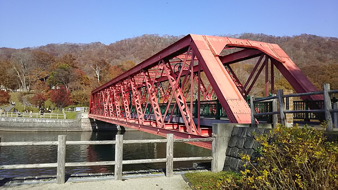
Iron bridge in Chitose City
Photo by Takisaw (CC BY-SA 4.0)

Of the city-designated Yamasen Railway Bridge, the city says it is British-made and was built in 1899 (Meiji 32) between Sunagawa and Moseushi, then moved to Lake Shikotsu as a bridge for the Oji Paper Company's private light railway (the Yamasen line). It was donated to the city in 1967 (Showa 42) and is now a footbridge.

  • 1899 (Meiji 32)
  • British-made
  • Chitose City Tangible Cultural Property, 1999

02 / Jomon earthen mask

At the mouth of a Jomon grave,a clay mask lay face up.

Jomon earthen mask in Chitose City
Photo by タクナワン (CC0)

The earthen mask from the Mamachi site was found in a grave of the Final Jomon period, about 2,300 years ago, and is 17.9 cm high and 18.4 cm wide. The Agency for Cultural Affairs' commentary says it was found at the northwest edge of the grave's mouth, lying face up. The city says one theory holds that it was attached to a grave marker.

  • About 2,300 years ago
  • 17.9 cm high, 18.4 cm wide
  • National Important Cultural Property, 1988

03 / Salmon fishing

A wheel turned only by the river's flowcatches salmon, with no electricity.

Salmon fishing in Chitose City
Photo by 100yen (CC BY-SA 3.0)

The city's tourism site says the Indian water wheel on the Chitose River is a fish-catching wheel set up in 1896 (Meiji 29) to catch adult salmon. It adds that, unlike other wheels in Hokkaido, only the one on the Chitose River turns on water power alone, without electricity.

  • Set up in 1896 (Meiji 29)
  • Water power only, no electricity
  • In place from mid-August to early December

Chitose City from the sky

Now and 1974–78. Tap a photo to zoom in.

Wide (about 6 km across)

Close (about 1.5 km across)

Now (shot October–November 2011)Shot 1974–78

Source: Geospatial Information Authority of Japan (GSI) GSI Tiles(全国最新写真(シームレス)/国土画像情報(第一期:1974〜1978年撮影))

Open in GSI Maps (now)Open in GSI Maps (1974–78)

Living here

About 30 minutes from Sapporo to Chitose Station by rapid train.

  • about 100,000 people

The Chitose City Council's guide says it takes about 30 minutes by the Rapid Airport train from JR Sapporo Station to JR Chitose Station, and about 15 minutes on foot from Chitose Station to City Hall (updated April 22, 2021). The gateway is Chitose Station.

People living here
97,950people
19952020

+2.4% since 2015

84,866 → 97,950

Area
594.5km²

197.54km² of it habitable

2024

Households
43,809households

2.2 people per household

2020

Rent (average for rentals)
46,908yen

National average 60,630 yen

2023

Healthcare
7 hospitals / 57 clinics

6.5 per 10,000 people

2023

Area594.5km²Habitable land197.54km² / 33%
Area and habitable land at the same scalee-Stat B1101 / B1103
Children waiting for childcare
—12 nurseries and similar
Home purchase subsidy
—
Average annual temperature
—

These 3 items are waiting on a nationwide data source. We do not fill them with estimates.

Shape

Borders 8 municipalities.

Chitose City in Japan42.821°N 141.651°E
TokyoOsakaChitose City
Territory of Chitose City
Boundaries: National Land Numerical Information (Administrative Area Data), MLIT. Processed by Machigatari.Lakes: National Land Numerical Information (Lake Data), MLIT. Processed by Machigatari. Prepared with the approval of the Director-General of the Geospatial Information Authority of Japan, using its Digital Map 25000 (Spatial Data Framework) and Digital Map 25000 (Place Names and Public Facilities). (承認番号 平27情使、第585号)

North to south

30.2km

Travel times per leg are not published by the municipality, so they are not shown.

Chitose City isthis kind of town.

  1. 01The city describes the Kiusu Earthwork Burial Circles as a communal graveyard made about 3,200 years ago in the Late Jomon period, and it is a National Historic Site (designated in 1979). Soil dug from a round pit was piled around it as an embankment, and the pit inside became individual graves. The city says the site contains nine such circles and gives the largest as 83 m across. In 2021 it was inscribed as part of the World Heritage property "Jomon Prehistoric Sites in Northern Japan"
  2. 02The animal-shaped clay object from the Bibi 4 site is a National Important Cultural Property (designated in 1979); the city describes it as 31.5 cm long, in a shape that could be a turtle, waterbird, flying squirrel or seal. The Usakumai Site Group is a National Historic Site (designated in 1979), and the city says 146 hectares in total, including 20 sites along the Naibetsu River, are protected
  3. 03The city says the Chitose area was once called "Shikotsu" in Ainu, meaning "a large hollow", and was renamed "Chitose" in 1805 (Bunka 2) after the cranes there. The origin is written on the back of the zushi, a cabinet that held a Benzaiten image, at Kamakka Shrine within the grounds of Chitose Shrine; the cabinet is a city-designated Tangible Cultural Property (designated in 1977)

If something caught your eye, ask the town itself.