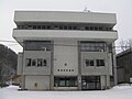
Kanashibetsu Romanza, Utashinai City
Article

01227 / うたしないし

Hokkaido

Utashinai City

A mining hall in a Japan Heritage story.

Kanashibetsu Romanza

Photo by Katakanano (CC BY-SA 3.0)

01 / Penkeutashunai River

An Ainu river name, "a stream withplenty of sand," is said to be the city's name.

The city says its name comes from the Penkeutashunai River, which runs east to west through town. In Ainu the name means "a stream with plenty of sand." When the Hokkaido Colliery and Railway line opened in 1891, the city says, that meaning was taken and the place named Utashinai.

  • Ainu: "a stream with plenty of sand"
  • 1891: named when the railway opened
  • River runs east to west

02 / Utashinai Line

The line just before closure,in about 20 minutes of video.

Utashinai Line in Utashinai City
Photo by Spaceaero2 (CC BY-SA 3.0)

The Utashinai Line closed in 1988. At the local museum Yumetsumugi, a seat from a real train and a monitor show video of the ride from Utashinai Station to Sunagawa Station, about 20 minutes, filmed just before the line closed.

  • 1988: line closed
  • About 20 minutes, Utashinai to Sunagawa
  • Seat from a real train car

03 / Sea of clouds, Mt. Kamoi

On a spring or autumn dawn, a seaof clouds may fill the view from Mt. Kamoi.

The city describes the sea of clouds seen from the summit of Mt. Kamoi as a natural phenomenon in which radiative cooling produces fog and stratus over a wide area. It is most likely in spring or autumn, and is said to form easily from dawn to early morning when humidity is high.

  • Most likely in spring or autumn
  • Forms from dawn to early morning
  • Seen from the Mt. Kamoi summit

Utashinai City from the sky

Now and 1974–78. Tap a photo to zoom in.

Wide (about 6 km across)

Close (about 1.5 km across)

Now (shot June 2015)Shot 1974–78

Source: Geospatial Information Authority of Japan (GSI) GSI Tiles(全国最新写真(シームレス)/国土画像情報(第一期:1974〜1978年撮影))

Open in GSI Maps (now)Open in GSI Maps (1974–78)

Living here

No station; 13 minutes by bus from Akabira.

  • about 3,000 people

There is no railway station in the city. The Utashinai Line bus of Hokkaido Chuo Bus runs from the Akabira Station stop to the Utashinai Shigai stop with no change. In the timetable revised October 1, 2026, it takes 13 minutes on weekdays, weekends and holidays alike.

People living here
2,989people
19952020

−16.6% since 2015

6,867 → 2,989

Area
55.95km²

14.02km² of it habitable

2024

Households
1,424households

2.1 people per household

2020

Rent (average for rentals)
21,794yen

National average 60,630 yen

2023

Healthcare
1 hospital / 3 clinics

13.4 per 10,000 people

2023

Area55.95km²Habitable land14.02km² / 25%
Area and habitable land at the same scalee-Stat B1101 / B1103
Children waiting for childcare
—1 nurseries and similar
Home purchase subsidy
—
Average annual temperature
—

These 3 items are waiting on a nationwide data source. We do not fill them with estimates.

ACCESS

Where you can go from here.

Utashinai City in Japan43.521°N 142.034°E
TokyoOsakaUtashinai City
Utashinai City Hall
歌志内市役所2011
  • to AkabiraLocal bus13min

Travel times follow 北海道中央バス『滝川路線 時刻表』(https://www.chuo-bus.co.jp/city_route/pdf/TAKIKAWA.pdf ・2026年10月1日改正。PDFの2ページ目を画像で目視)の歌志内線。赤平駅前発→歌志内市街着。平日:6:20→6:33・7:30→7:43・8:50→9:03・9:45→9:58・10:45→10:58・12:45→12:58・14:55→15:08・15:45→15:58・16:45→16:58・17:45→17:58・19:00→19:13。土日祝:7:15→7:28・8:50→9:03・10:45→10:58・12:45→12:58・14:45→14:58・16:45→16:58・17:45→17:58。すべて13分。時刻表の所要の表示も『赤平駅前→歌志内市街 13分』 (checked 2026-10-29). They vary by time of day.

Shape

Borders 4 municipalities.

Territory of Utashinai City
Boundaries: National Land Numerical Information (Administrative Area Data), MLIT. Processed by Machigatari.Lakes: National Land Numerical Information (Lake Data), MLIT. Processed by Machigatari. Prepared with the approval of the Director-General of the Geospatial Information Authority of Japan, using its Digital Map 25000 (Spatial Data Framework) and Digital Map 25000 (Place Names and Public Facilities). (承認番号 平27情使、第585号)

Utashinai City isthis kind of town.

  1. 01Kanashibetsu Romanza is the former Kamiuta Hall, then a welfare facility for mine employees, and a component of the Japan Heritage story on coal, railways and ports. It was also the setting of a 1984 TV drama
  2. 02The city says its name comes from the Penkeutashunai River and explains it as Ainu for "a stream with plenty of sand." The Utashinai Line closed in 1988, and the local museum tells its story in video
  3. 03From Mt. Kamoi's summit, a sea of clouds can sometimes be seen in spring or autumn. The city has no railway station; a bus runs from the Akabira Station stop to the Utashinai Shigai stop

See the town as it is now.

Source: Wikidata (P2002, P2003, P2013, P2397)

If something caught your eye, ask the town itself.