Sagakei, Miyato Island cliffs, Higashimatsushima City
Article

04214 / ひがしまつしまし

Miyagi Prefecture

Higashimatsushima City

Pines grip a cliff eroded by waves.

Sagakei, Miyato Island cliffs

Photo by pastaitaken (CC BY 3.0)

01 / Satohama Shell Mound

From the Final Jomon at the latest,a pottery salt-making site stood on the shore.

The Satohama Shell Mound, a National Historic Site, lies in the west of Miyato Island. The Agency for Cultural Affairs commentary notes that by the Final Jomon at the latest, a pottery salt-making site operated on the shore, and says the salt was carried to hill settlements some 20 to 30 km away, with stone for tools brought back in return.

  • National Historic Site, 1995
  • Salt carried some 20 to 30 km inland
  • West of Miyato Island

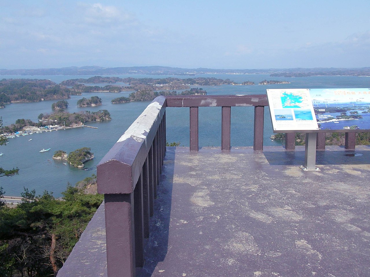
02 / Ootakamori

From a mountain on the Shimayama 100 list,you look over some 260 islands in the bay.

Ootakamori in Higashimatsushima City
Photo by Junpei Satoh (CC BY-SA 3.0)

The city describes this 105.8 m mountain at the center of Miyato Island as chosen for the Shimayama 100 list. The summit is about 20 minutes from the trailhead, and the observation deck looks out over the islands. Ootakamori Yakushido, on the island, is a nationally Registered Tangible Cultural Property (building).

  • Height 105.8 m
  • About 20 minutes from trailhead to summit
  • Yakushido registered nationally, 2022

03 / Yamoto Yokoana

Sue ware inscribed "Otoneri"came from the cave tombs.

Yamoto Yokoana, part of the Akai Kangai Sites, is a group of cave tombs laid out along an east-facing hillside for about 1.5 km, with 113 confirmed so far. Sue ware inscribed "Otoneri" was among the finds, and the tombs are considered the burial ground of officials who served at the Oshika district office or stockade.

  • Akai Kangai Sites: National Historic Site, 2021
  • 113 cave tombs confirmed
  • Sue ware inscribed "Otoneri"

Higashimatsushima City from the sky

Now and 1974–78. Tap a photo to zoom in.

Wide (about 6 km across)

Close (about 1.5 km across)

Now (shot May 2020)Shot 1974–78

Source: Geospatial Information Authority of Japan (GSI) GSI Tiles(全国最新写真(シームレス)/国土画像情報(第一期:1974〜1978年撮影))

Open in GSI Maps (now)Open in GSI Maps (1974–78)

Living here

From Sendai Station to Yamoto Station, about 40 minutes on the Senseki-Tohoku Line.

  • about 40,000 people

The city's Access page (updated May 15, 2018) gives the JR route to City Hall as about 40 minutes from Sendai Station to Yamoto Station on the Senseki-Tohoku Line, or about 70 minutes on the Senseki Line. City Hall is about 740 m from Yamoto Station.

People living here
39,098people
20052020

−1% since 2015

43,235 → 39,098

Area
101.3km²

73.73km² of it habitable

2024

Households
14,476households

2.7 people per household

2020

Rent (average for rentals)
37,424yen

National average 60,630 yen

2023

Healthcare
2 hospitals / 24 clinics

6.6 per 10,000 people

2023

Area101.3km²Habitable land73.73km² / 73%
Area and habitable land at the same scalee-Stat B1101 / B1103
Children waiting for childcare
—8 nurseries and similar
Home purchase subsidy
—
Average annual temperature
—

These 3 items are waiting on a nationwide data source. We do not fill them with estimates.

Shape

Borders 3 municipalities.

Higashimatsushima City in Japan38.426°N 141.211°E
TokyoOsakaHigashimatsushima City
Territory of Higashimatsushima City
Boundaries: National Land Numerical Information (Administrative Area Data), MLIT. Processed by Machigatari.Lakes: National Land Numerical Information (Lake Data), MLIT. Processed by Machigatari. Prepared with the approval of the Director-General of the Geospatial Information Authority of Japan, using its Digital Map 25000 (Spatial Data Framework) and Digital Map 25000 (Place Names and Public Facilities). (承認番号 平27情使、第585号)

North to south

18.2km

Travel times per leg are not published by the municipality, so they are not shown.

Higashimatsushima City isthis kind of town.

  1. 01Sagakei is a sea cliff on the peninsula at the southern tip of Miyato Island; the Japan Tourism Agency's commentary database describes a gorge made by ocean waves rather than a stream, with pine trees gripping the vertical rock with long roots
  2. 02The Satohama Shell Mound and the Akai Kangai Sites (including Yamoto Yokoana) are National Historic Sites, Ootakamori Yakushido is a nationally Registered Tangible Cultural Property (building), and the Enzu-no-wari of Tsukihama is a nationally designated Important Intangible Folk Cultural Property
  3. 03The Moon-Viewing Pine and an old cedar at the shrine in Yamoto are Prefectural Natural Monuments; the pine is a Japanese black pine on the south side of a city road, and the cedar is the shrine's sacred tree

If something caught your eye, ask the town itself.

From this town's themes