鳩山町から見た堂平山と笠山.jpg
Article

11348 / はとやままち

Saitama Prefecture 比企郡

Hatoyama Town

A satoyama town on the Hiki Hills' edge.

Photo by Koda6029 (CC BY-SA 4.0)

01 / Space

The Earth as satellites see it,received by a 13-metre dish.

Higashimatsuyama Earth Observation Center Entrance 1.jpg
Photo by 京浜にけ (CC BY-SA 3.0)

In October 1978 the Earth Observation Center was set up amid the town's greenery. Now a JAXA facility, its 13-metre parabolic antenna receives observation data from the satellite Daichi-4 (だいち4号) via a data relay satellite, for use in disaster monitoring and in understanding environmental problems. There is even an asteroid named after the town: Hatoyamamachi.

  • Founded October 1978
  • 13-metre antenna
  • Asteroid Hatoyamamachi

02 / Kiln sites

Roof tiles fired here went40 km south to Musashi Kokubunji.

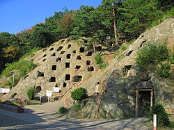
Good clay, firewood and gentle slopes for building kilns: kiln sites from the 6th to the 10th century spread across almost the whole town. In the mid-8th century, centred on the Shinnuma kiln site, huge numbers of tiles were fired for the founding of Musashi Kokubunji temple and carried some 40 km south. In 2023 the Minami-Hiki kiln sites (南比企窯跡) became the town's first National Historic Site.

  • Tiles for the founding of Musashi Kokubunji
  • Carried about 40 km south
  • National Historic Site, 2023

03 / New town

In 1974, a new town roseon the farming hills.

Hatoyama New town 1.JPG
Photo by Ebiebi2 (CC BY-SA 3.0)

In 1974 residents began moving into Hatoyama New Town in what had been a purely farming village, and for a time Hatoyama had the fastest population growth in the prefecture. Nearly all of its roughly 137 ha lies within the Hiki Hills Prefectural Natural Park. In 2017 a former Seiyu store floor was reborn as the Community Marché, home to a relocation support centre and a shared office.

  • Residents from 1974
  • About 137 ha
  • Marché opened 2017

Living here

20 minutes by bus from Sakado Station.

  • about 10,000 people
  • Rural district town

There is no railway station in town. The town directs visitors to the Kawagoe Kanko bus bound for Ōhashi from the north exit of Sakado Station on the Tobu Tojo Line, about 20 minutes to the Yakuba-mae (役場前, "Town Office") stop. Within town, the shared on-demand taxi Hatotaku (はとタク) takes residents anywhere in town for 200 yen a ride. Medical care is free up to age 18, and school lunches at town kindergartens and schools are free.

People living here
13,560people
19952020

−5.4% since 2015

17,973 → 13,560

Area
25.73km²

16.62km² of it habitable

2024

Households
5,399households

2.5 people per household

2020

Rent (average for rentals)
—
Healthcare
1 hospital / 6 clinics

5.2 per 10,000 people

2023

Area25.73km²Habitable land16.62km² / 65%
Area and habitable land at the same scalee-Stat B1101 / B1103
Children waiting for childcare
—2 nurseries and similar
Home purchase subsidy
—
Average annual temperature
—

These 3 items are waiting on a nationwide data source. We do not fill them with estimates.

ACCESS

Where you can go from here.

Hatoyama Town in Japan35.981°N 139.334°E
OsakaHatoyama Town
役場前
役場前2012
  • to SakadoLocal bus20min

Travel times follow 町公式「アクセス」(役場の案内)の「最寄りの駅・・・東武東上線坂戸駅よりバスで約20分」。川越観光自動車の事業者公式の時刻表(大橋線〔坂戸駅-大橋〕・2026-09-24 現在)でいまの運行を確かめた (checked 2026-09-24). They vary by time of day.

Shape

Borders 6 municipalities.

Territory of Hatoyama Town
Boundaries: National Land Numerical Information (N03)

North to south

5.4km

東松山市, ときがわ町, 越生町, 坂戸市, 毛呂山町, 嵐山町

Hatoyama Town isthis kind of town.

  1. 01JAXA's Earth Observation Center sits in the wooded hills, its 13-metre antenna receiving data from Earth observation satellites
  2. 02Kiln sites that fired roof tiles for Musashi Kokubunji in the Nara period cover almost the whole town, and the Minami-Hiki kiln sites became a National Historic Site in 2023
  3. 03In Hatoyama New Town, where residents arrived from 1974, a former Seiyu store floor has become a hub for newcomers and community life

If something caught your eye, ask the town itself.