Falls basin of the Shomyo-daki.jpg
Article

16323 / たてやままち

Toyama Prefecture 中新川郡

Tateyama Town

A waterfall that drops 350 m in 4 steps.

Shōmyō Falls

Photo by kahusi (CC BY-SA 3.0)

01 / Nunobashi Kanjōe

Women barred from the mountaincrossed a cloth bridge, blindfolded.

In the Edo period, when women were forbidden to climb Mount Tate, the Nunobashi Kanjōe (布橋灌頂会) was held at Ashikuraji (芦峅寺) for them. Women in white robes, blindfolded, cross the Nunobashi bridge laid with white cloth, in a rite of rebirth. It died out in the Meiji era and was revived in 1996 after about 130 years. It is now held once every three years; in 2026 it takes place on 27 September.

  • Revived in 1996 after about 130 years
  • Once every three years
  • 27 September 2026

02 / Tateyama Murodō

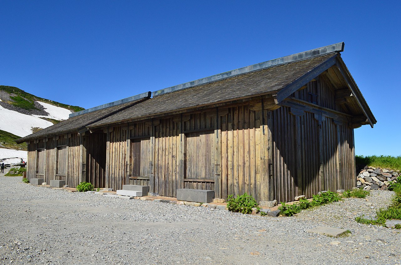
At 2,450 m standsa mountain hut built in 1726.

Tateyama Murodo-2.jpg
Photo by Saigen Jiro (CC0)

On the Murodō plateau stands the Murodō (立山室堂), where pilgrims to Mount Tate stayed and worshipped the peak from afar. With support from the Maeda family of the Kaga domain, the north building went up in 1726 and the south building in 1771. Used as a mountain hut from the Meiji era on, it was dismantled and restored in 1992–94 and is now open to the public. It became an Important Cultural Property in 1995.

  • Altitude 2,450 m
  • North building 1726, south building 1771
  • Important Cultural Property, 1995

03 / Glaciers

Glaciers, thought not to exist in Japan,lay on the east face of the Tateyama range.

Mount Tate and Mount Tsurugi from Mount Kashimayari (2003-11-02).jpg
Photo by Alpsdake (CC BY-SA 4.0)

Japan was long thought to have no glaciers today. From 2009 the Tateyama Caldera Sabo Museum of Toyama Prefecture surveyed the Gozenzawa (御前沢) snowfield on the east face of Mount Oyama and the Sannomado (三ノ窓) and Komado (小窓) snowfields on the east face of Mount Tsurugi, and found ice more than 30 m thick on the move. In April 2012 the three were recognized as Japan's first existing glaciers.

  • April 2012: Japan's first existing glaciers
  • Ice over 30 m thick
  • Gozenzawa, Sannomado, Komado

Living here

Town hall, hospital and library within 1 km of the station.

  • about 20,000 people
  • Rural district town

There is no Hokuriku Shinkansen station in town; the Toyama Chihō Railway Tateyama Line runs through Gohyakkoku Station up to Tateyama Station. Within 1 km of Gohyakkoku Station, the town centre, are the town hall, police, fire station, hospital, post office and library. Toyama Station and Toyama Airport are about 20 minutes by car. Rice in school lunches is 100% Koshihikari grown in town.

People living here
24,792people
19952020

−5.8% since 2015

27,444 → 24,792

Area
307.29km²

161.61km² of it habitable

2024

Households
9,047households

2.7 people per household

2020

Rent (average for rentals)
45,474yen

National average 60,630 yen

2023

Healthcare
1 hospital / 12 clinics

5.2 per 10,000 people

2023

Area307.29km²Habitable land161.61km² / 53%
Area and habitable land at the same scalee-Stat B1101 / B1103
Children waiting for childcare
—9 nurseries and similar
Home purchase subsidy
—
Average annual temperature
—

These 3 items are waiting on a nationwide data source. We do not fill them with estimates.

Shape

Borders 5 municipalities across 1 prefectures.

Tateyama Town in Japan36.664°N 137.314°E
TokyoOsakaTateyama Town
Territory of Tateyama Town
Boundaries: National Land Numerical Information (N03)

North to south

20.6km

Toyama Prefecture
富山市, 上市町, 黒部市, 舟橋村
Nagano Prefecture
大町市

Travel times per leg are not published by the municipality, so they are not shown.

Tateyama Town isthis kind of town.

  1. 01On the Shōmyō River, the Shōmyō Falls (称名滝), a national Place of Scenic Beauty, drop about 350 m in four steps; the Toyama side of the Alpine Route, up to Kurobe Dam, lies within the town
  2. 02At Ashikuraji, the Nunobashi Kanjōe, a rite for women who were barred from climbing Mount Tate, is held once every three years
  3. 03The Tateyama Murodō of 1726 stands at 2,450 m, and on the east face of the Tateyama range Japan's first existing glaciers were recognized in 2012

See the town as it is now.

Source: Wikidata (P2002, P2003, P2013, P2397)

If something caught your eye, ask the town itself.