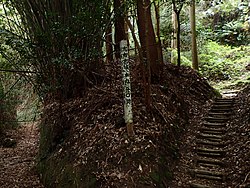
照日神社 - panoramio.jpg
Article

46468 / おおさきちょう

Kagoshima Prefecture 曽於郡

Osaki Town

Settlers enshrined Ise's god, it's said.

Teruhi Shrine, Arasano

Photo by SATcatype (CC BY-SA 3.0)

01 / Kiirido

Huge amounts of timber floated on mudformed the base of the Kiirido road.

Sammonji was a muddy wetland. The town board of education's guidebook writes that huge amounts of timber were floated on the marsh to make a base, completing the shortest road, Kiirido, from the magistrate's office to the Nagayoshi plateau. The method is also said to have been used in building the Furue Line, opened in 1935, across Sammonji.

  • Kiirido, the shortest road
  • Base of floated timber
  • 1935: Furue Line opened

02 / Tumulus No. 10, Jinryo

Excavation of Jinryo Tumulus No. 10turned up shield-bearer haniwa.

神領10号墳出土 須恵器・土師器・盾持人形埴輪 (複製).JPG
Photo by Saigen Jiro (Public domain)

Yokose Tumulus is a national historic site, and the guidebook describes it as a large keyhole-shaped tumulus built in the mid-5th century. At nearby Jinryo Tumulus No. 10, excavations in fiscal 2007-2009 yielded shield-bearer haniwa, early Sue ware and iron weapons; it is thought to be linked to the person buried in Yokose.

  • 1943: national historic site
  • Excavated in fiscal 2007-2009
  • Shield-bearer haniwa, early Sue ware, iron weapons

03 / Tsuma Shrine

The old approach's stone wallsare built of pumice.

Tsuma Shrine Morokata 2016.JPG
Photo by Sanjo (CC BY-SA 3.0)

Along the former approach to Tsuma Shrine, stone walls built of pumice remain; the guidebook writes that laying walls with pumice is a trait of the Osaki area. The worship hall, main hall and four subsidiary shrines are Registered Tangible Cultural Properties, and the main hall's eaves bear zodiac reliefs. A bronze mirror is nationally designated.

  • Pumice-laid stone walls
  • Worship hall, main hall, 4 subsidiary shrines registered
  • Zodiac reliefs

Living here

No railway; an airport bus reaches the roadside station.

  • about 10,000 people
  • Rural district town

Osaki has no railway; the Japanese National Railways Osumi Line closed in 1987. The town's website describes an airport bus operated by Kagoshima Kotsu that links the roadside station Michinoeki Nogata Arasano and Kagoshima Airport in about 65 minutes via expressway.

People living here
12,385people
19952020

−6.5% since 2015

16,480 → 12,385

Area
100.64km²

64.81km² of it habitable

2024

Households
5,906households

2.1 people per household

2020

Rent (average for rentals)
—
Healthcare
0 hospitals / 7 clinics

5.7 per 10,000 people

2023

Area100.64km²Habitable land64.81km² / 64%
Area and habitable land at the same scalee-Stat B1101 / B1103
Children waiting for childcare
—6 nurseries and similar
Home purchase subsidy
—
Average annual temperature
—

These 3 items are waiting on a nationwide data source. We do not fill them with estimates.

Shape

Borders 4 municipalities.

Osaki Town in Japan31.429°N 131.006°E
TokyoOsakaOsaki Town
Territory of Osaki Town
Boundaries: National Land Numerical Information (N03)

North to south

17.6km

志布志市, 鹿屋市, 東串良町, 曽於市

Travel times per leg are not published by the municipality, so they are not shown.

Osaki Town isthis kind of town.

  1. 01Teruhi Shrine in Arasano began, the town's newsletter writes, when people who moved from Settsu, Kawachi and Izumi in the Genroku era enshrined the divine spirit of Ise Shrine; its grounds' plant community is a town Natural Monument
  2. 02Yokose Tumulus, a large keyhole-shaped tomb, became a national historic site in 1943; shield-bearer haniwa came from nearby Jinryo Tumulus No. 10, and Sammonji is said to have a road, Kiirido, built on a base of floated timber
  3. 03Tsuma Shrine's worship hall, main hall and four subsidiary shrines are registered cultural properties; Teruhi Shrine's kagura is a town Intangible Cultural Property; a stick dance is performed at Arasano's spring festival every three years, and mukuge flowers around Obon are called bonchika

If something caught your eye, ask the town itself.