Hiraide Spring, near the ruins, Shiojiri City
Article

20215 / しおじりし

Nagano Prefecture

Shiojiri City

Near ruins, a spring unfrozen in winter.

Hiraide Spring, near the ruins

Photo by Saigen Jiro (CC0)

01 / Kamai-an

Sugae Masumi spent over a year here;the hermitage also served as a village school.

Kamai-an in Shiojiri City
Photo by Qurren (CC BY-SA 4.0)

A Prefectural Historic Site. The city says the hermitage stands where the Mimura family is said to have had a residence in the Sengoku period, and is estimated to date from the mid-18th century. Sugae Masumi stayed over a year from 1783 and is known for writing there; it also served as a village school.

  • Prefectural Historic Site, September 20, 2001
  • Sugae Masumi stayed over a year from 1783 (Tenmei 3)
  • Estimated built in the mid-18th century
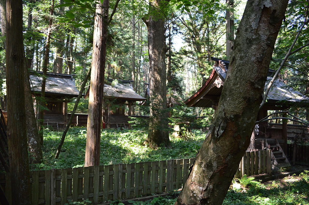
02 / Ono Shrine main halls

Two main halls of the same size and style;in an Onbashira year, the deity is moved.

Ono Shrine main halls in Shiojiri City
Photo by Saigen Jiro (CC0)

A Nagano Prefectural Treasure. The city says the shrine buildings were rebuilt by the Matsumoto domain after a fire in 1672 (Kanbun 12), and the two main halls, the same in size and style, exchange the enshrined deity in an Onbashira Festival year. The shrine is said to have been one with Yahiko Shrine, its precincts divided in the Azuchi-Momoyama period.

  • Nagano Prefectural Treasure, September 10, 1992
  • Four buildings designated: two main halls, Hachimangu main hall, Chokushiden
  • Rebuilt after a fire in 1672 (Kanbun 12)

03 / Gobara post town

On both sides of the road, 40-ken house plots,then 60-ken fields behind, run back.

Gobara post town in Shiojiri City
Photo by Heritage13 (CC BY-SA 4.0)

A City Historic Site. The city says this relay post town, after the Zenkoji Road (Hokkoku Wakiokan) branched from the Nakasendo at Seba, had house frontages wider than other post towns, gabled gable-end-entry honmune-zukuri houses with sparrow-dance ornaments, and a front garden before each house. Three wells are presumed; the wholesale house's well has been restored.

  • City Historic Site, January 13, 1970
  • Depth: 40 ken of house plots on both sides, then 60 ken of fields
  • Three wells presumed at the start

Shiojiri City from the sky

Now and 1974–78. Tap a photo to zoom in.

Wide (about 6 km across)

Close (about 1.5 km across)

Now (shot September–October 2021)Shot 1974–78

Source: Geospatial Information Authority of Japan (GSI) GSI Tiles(全国最新写真(シームレス)/国土画像情報(第一期:1974〜1978年撮影))

Open in GSI Maps (now)Open in GSI Maps (1974–78)

Living here

At the southern end of the Matsumoto Basin, near the middle of Nagano Prefecture.

  • about 70,000 people
  • 2 hours to a city centre

The city spans 17.7 km east to west and 37.8 km north to south, with an area of about 289.98 km² (a reference value because part of the boundary is undetermined). It became a city in 1959 from one town and four villages, and Seba Village joined in 1961 and Narakawa Village in 2005. The gateway is Shiojiri Station, about a 7-minute walk from its east exit to the Shiojiri General Cultural Center.

People living here
67,241people
20052020

+0.2% since 2015

68,346 → 67,241

Area
289.98km²

71.6km² of it habitable

2024

Households
27,997households

2.4 people per household

2020

Rent (average for rentals)
49,945yen

National average 60,630 yen

2023

Healthcare
5 hospitals / 43 clinics

7.1 per 10,000 people

2023

Area289.98km²Habitable land71.6km² / 25%
Area and habitable land at the same scalee-Stat B1101 / B1103

Population from 2005 onward (municipal boundary changed).2005-04-01 に編入合併(楢川村)。2005年調査から市域が変わっている。

Children waiting for childcare
—14 nurseries and similar
Home purchase subsidy
—
Average annual temperature
—

These 3 items are waiting on a nationwide data source. We do not fill them with estimates.

ACCESS

Where you can go from here.

Shiojiri City in Japan36.115°N 137.953°E
OsakaShiojiri City
Shiojiri Station
塩尻駅2021
  • to ShinjukuJR limited express145min
  • to NagoyaLtd. exp. Shinano113min

Travel times follow JR東日本『駅の時刻表』(2026年10月号のダイヤ。JR時刻表2026年10月号に基づく)。新宿駅 中央本線 下りの特急あずさ(平日 0866050・土曜・休日 0866051)と、塩尻駅 中央本線 下りの特急しなの(平日 0774010・土曜・休日 0774011)の各列車ページ (checked 2026-10-20). They vary by time of day.

Shape

Borders 8 municipalities.

Territory of Shiojiri City
Boundaries: National Land Numerical Information (Administrative Area Data), MLIT. Processed by Machigatari.Lakes: National Land Numerical Information (Lake Data), MLIT. Processed by Machigatari. Prepared with the approval of the Director-General of the Geospatial Information Authority of Japan, using its Digital Map 25000 (Spatial Data Framework) and Digital Map 25000 (Place Names and Public Facilities). (承認番号 平27情使、第585号)

Shiojiri City isthis kind of town.

  1. 01Hiraide Spring is a City Historic Site; its water averages 10 degrees all year, flows at 45 liters per second, and does not freeze in winter. About 200 m from the Hiraide Site, a National Historic Site, it is described by the city as a factor in the formation of a settlement
  2. 02Kamai-an is a Prefectural Historic Site where Sugae Masumi stayed for over a year from 1783 (Tenmei 3). The two main halls of Ono Shrine, a Nagano Prefectural Treasure, are the same in size and style, and the deity is moved from one to the other in an Onbashira Festival year
  3. 03The Gobara post town's plots and old wells are a City Historic Site, and the city's regional plan records Yanagi Muneyoshi as praising the whole post town as 'a magnificent single work.' Narai-juku and Kisohirasawa are Important Preservation Districts for Groups of Traditional Buildings, and the 3,729 Kiso lacquerware tools and products are a National Important Tangible Folk Cultural Property

See the town as it is now.

Source: Wikidata (P2002, P2003, P2013, P2397)

If something caught your eye, ask the town itself.