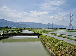
Ushibuse Kaidanko, French style, Matsumoto City
Article

20202 / まつもとし

Nagano Prefecture

Matsumoto City

The river channel is a stone staircase.

Ushibuse Kaidanko, French style

Photo by Douglas Perkins (CC BY 4.0)

01 / Castle site

The military governor's residence on spring-fed groundwas found in an enclosure ringed by a moat.

Castle site in Matsumoto City
Photo by Lemmingdead at Japanese Wikipedia (Public domain)

Igawa Castle Site, part of the nationally designated Ogasawara Clan Castle Sites, lies in a spring-fed area near a river confluence. Excavation uncovered a rectangular enclosure, 100 m north to south and 70 m wide, ringed by a moat that used the Zunashi River and its old channel; in the south-east corner is a mound said to mark a turret platform.

  • National Historic Site, designated 2017
  • 100 m north-south, 70 m wide
  • Mound said to be a turret platform

02 / School

Windows of paper shoji, not glass:it is said to have been known as the 'Shoji School'.

School in Matsumoto City
Photo by Qurren (CC BY-SA 3.0)

This two-storey wooden schoolhouse was built in 1885 (Meiji 18) by two local villages with village funds and donations. The master carpenter was Sasaki Kiju, a local man, and the model was Kaichi School. The sliding shoji windows are now doubled with glass doors for upkeep.

  • Prefectural Treasure, designated 1985
  • Built 1885
  • Village funds and donations

03 / Courthouse

A courthouse with a central carriage porch,its whole design done in the Japanese style.

Courthouse in Matsumoto City
Photo by Mt.Jounen (CC BY-SA 3.0)

Built in 1908 on the site of the Ninomaru Palace of Matsumoto Castle, the building was moved and restored in 1982 to the Matsumoto City Rekishi no Sato in Shimadachi. Its plan is H-shaped, and the courtrooms have a raised step for the judge's seat. When demolition was decided, a citizens' group campaigned to save it.

  • Important Cultural Property, designated 2017
  • Built 1908
  • H-shaped plan

Matsumoto City from the sky

Now and 1974–78. Tap a photo to zoom in.

Wide (about 6 km across)

Close (about 1.5 km across)

Now (shot September 2011)Shot 1974–78

Source: Geospatial Information Authority of Japan (GSI) GSI Tiles(全国最新写真(シームレス)/国土画像情報(第一期:1974〜1978年撮影))

Open in GSI Maps (now)Open in GSI Maps (1974–78)

Living here

A city that merged with one town and four villages, 52.2 km across.

  • about 240,000 people

Matsumoto took in Shiga, Azumi, Nagawa and Azusagawa villages in April 2005 and Hata Town in March 2010. It covers 978.47 km² (as of 1 October 2014), 52.2 km from east to west and 41.3 km from north to south. The gateway is JR Matsumoto Station, where the Limited Express Azusa and the Limited Express Shinano arrive.

People living here
241,145people
2010

−0.9% since 2015

243,037 → 241,145

Area
978.47km²

233.33km² of it habitable

2024

Households
104,934households

2.3 people per household

2020

Rent (average for rentals)
52,048yen

National average 60,630 yen

2023

Healthcare
16 hospitals / 231 clinics

10.2 per 10,000 people

2023

Area978.47km²Habitable land233.33km² / 24%
Area and habitable land at the same scalee-Stat B1101 / B1103

Population from 2010 onward (municipal boundary changed).2005-04-01 に編入合併(四賀村・奈川村・安曇村・梓川村)。2005年調査から市域が変わっている。2010-03-31 に編入合併(波田町)。2010年調査から市域が変わっている。

Children waiting for childcare
—51 nurseries and similar
Home purchase subsidy
—
Average annual temperature
—

These 3 items are waiting on a nationwide data source. We do not fill them with estimates.

ACCESS

Where you can go from here.

Matsumoto City in Japan36.238°N 137.972°E
OsakaMatsumoto City
Matsumoto Station
松本駅2018
  • to ShinjukuJR limited express149min
  • to NagoyaLtd. exp. Shinano123min

Travel times follow JR東日本『駅の時刻表』2610版(中央本線 下り 新宿→松本。平日・土曜休日の両ページ)と、同サイトの特急しなの各号の『停車駅一覧』ページ(名古屋→長野。2610版) (checked 2026-10-21). They vary by time of day.

Shape

Borders 14 municipalities across 1 prefectures.

Territory of Matsumoto City
Boundaries: National Land Numerical Information (Administrative Area Data), MLIT. Processed by Machigatari.Lakes: National Land Numerical Information (Lake Data), MLIT. Processed by Machigatari. Prepared with the approval of the Director-General of the Geospatial Information Authority of Japan, using its Digital Map 25000 (Spatial Data Framework) and Digital Map 25000 (Place Names and Public Facilities). (承認番号 平27情使、第585号)

Matsumoto City isthis kind of town.

  1. 01In Uchida, Matsumoto, the Ushibuse River Main Channel (Ushibuse Kaidanko) is a stone channel with 19 tokogatame (bed sills) stepped along about 141 m of waterway from east to west; it was designed with channel works in France as a reference and is an Important Cultural Property
  2. 02South of Matsumoto Station lies Igawa Castle Site, where the Ogasawara clan, military governors of Shinano, kept a residence in the Muromachi period; with Hayashi Castle Site, a mountain castle, it forms the nationally designated Ogasawara Clan Castle Sites
  3. 03The Former Yamabe School is a Prefectural Treasure and the Former Matsumoto District Court building in Shimadachi is an Important Cultural Property, and the city also has the National Treasures Matsumoto Castle and Former Kaichi School, and Kamikochi and the Norikura highlands in the former Azumi Village

If something caught your eye, ask the town itself.