Azuma Kofun genmon.JPG
Article

09361 / みぶまち

Tochigi Prefecture 下都賀郡

Mibu Town

A tomb doorstone sits in a castle park.

Azuma Kofun, doorstone

Photo by Saigen Jiro (CC0)

01 / Anatomical atlas

A dissection organized by domain physicianssurvives in eight watercolor drawings.

In 1840, physicians of the Mibu domain organized a dissection held at an execution ground. The anatomical drawings were sketched in watercolor on eight sheets of Japanese paper and survive in the Kaitai Seizu, a town-designated cultural property. In 1850 the domain lord wrote of the importance of cowpox in a letter, and later had every resident of the domain vaccinated.

  • Dissection in 1840
  • Eight drawings
  • Letter of 1850

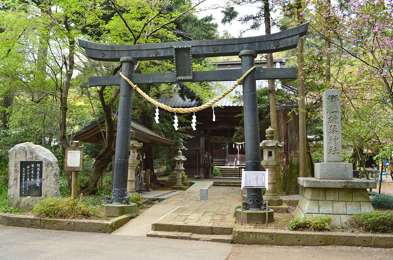
02 / Copper torii

A copper torii donated by a Mibu merchantbears the name of a caster from Sano.

Okoto-jinja torii.JPG
Photo by Saigen Jiro (CC0)

Donated in 1778 by a wealthy Mibu merchant, the copper torii of Okoto Shrine is an Inari-type torii with a plinth at the top of each pillar, carrying the shimaki beam, and cast Chinese lion figures sit on the base stones. The left pillar is inscribed with the words for a caster from Sano in Shimotsuke, and the prefecture credits the Maruyama family, leading Tenmyo casters.

  • Donated in 1778
  • Prefecturally designated (1989)
  • Left pillar names a Sano caster

03 / Honjin branch family

A branch of a honjin familyhas six registered properties.

Matsumoto-ke Jyutaku Warehouses.jpg
Photo by Suikotei (CC BY-SA 4.0)

The Matsumoto family branched off from the Matsumoto family that served as honjin, the official lodging for traveling lords, in the Edo period, and its first head also served as honjin for a time. The main house dates from 1912 and the three storehouses, front gate, and back gate and wall from about 1907. All six are Registered Tangible Cultural Properties. The house is privately owned and seen only from the road.

  • 6 Registered properties
  • Main house, 1912
  • Three storehouses, about 1907

Living here

Four Tobu Utsunomiya Line stations lie within the town.

  • about 40,000 people
  • Rural district town

The town measures 8.0 km east to west and 12.5 km north to south, and covers 61.06 km². The Omoi River runs along its west edge, the Kuro River through the middle and the Sugata River along the east, over nearly flat land 50 to 100 m above sea level. Its four Tobu Utsunomiya Line stations are Mibu, Kuniya, Omochanomachi and Yasuzuka. The town's guide says to ride the Tobu Nikko Line from Asakusa to Shin-Tochigi, change to the Tobu Utsunomiya Line, and ride about 13 minutes to Kuniya.

People living here
39,474people
19952020

−1.2% since 2015

39,823 → 39,474

Area
61.06km²

57.08km² of it habitable

2024

Households
15,894households

2.5 people per household

2020

Rent (average for rentals)
48,440yen

National average 60,630 yen

2023

Healthcare
1 hospital / 35 clinics

9.1 per 10,000 people

2023

Area61.06km²Habitable land57.08km² / 93%
Area and habitable land at the same scalee-Stat B1101 / B1103
Children waiting for childcare
—11 nurseries and similar
Home purchase subsidy
—
Average annual temperature
—

These 3 items are waiting on a nationwide data source. We do not fill them with estimates.

Shape

Borders 4 municipalities.

Mibu Town in Japan36.442°N 139.815°E
OsakaMibu Town
Territory of Mibu Town
Boundaries: National Land Numerical Information (N03)Lakes: National Land Numerical Information (Lake Data), MLIT. Processed by Machigatari. Prepared with the approval of the Director-General of the Geospatial Information Authority of Japan, using its Digital Map 25000 (Spatial Data Framework) and Digital Map 25000 (Place Names and Public Facilities). (承認番号 平27情使、第585号)

North to south

12.8km

下野市, 鹿沼市, 栃木市, 宇都宮市

Travel times per leg are not published by the municipality, so they are not shown.

Mibu Town isthis kind of town.

  1. 01The genmon-ishi taken from Azuma Kofun, which spans Tochigi City and Mibu, is a single block of tuff with a doorway cut through it, and is displayed in Mibu Castle Site Park
  2. 02A dissection organized by Mibu domain physicians in 1840 survives in eight watercolor drawings, the Kaitai Seizu, a town-designated cultural property
  3. 03The copper torii of Okoto Shrine, donated by a Mibu merchant in 1778, is prefecturally designated, and six structures of the Matsumoto family residences are Registered Tangible Cultural Properties

If something caught your eye, ask the town itself.