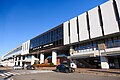
Takagi Kaikan.jpg
Article

09213 / なすしおばらし

Tochigi Prefecture

Nasushiobara City

The president himself designed the bank.

Takagi Kaikan, old Kuroiso Bank

Photo by Suikotei (CC BY 4.0)

01 / Sabigawa Fusekoshi

Water passed in a pentagonal tunnelbeneath a river that runs underground.

Sabigawa river dry riverbed.jpg
Photo by Kanohara (Public domain)

In 1885 the Nasu Sosui canal passed beneath the bed of the Sabigawa River, a river whose flow goes underground, through a tunnel of cut stone. Its cross-section was a pentagon, and it was about 267 m long. The gaps between the stones were filled with sulphur brought from Mount Nasu. A new tunnel beside it replaced the old one in 1969, and the shape of its outlet still remains.

  • Built 1885
  • About 267 m long
  • Pentagonal cross-section

02 / Former Aoki Villa

German influence shows stronglyin the frame and attic of this villa.

KyuAokikeNasuBettei20120901.jpg
Photo by 三人日 (CC BY-SA 3.0)

Aoki Shūzō, who served as minister to Germany and as foreign minister, built this villa on his own farm in 1888. It was designed by Matsugasaki Tsumunaga, and the Agency for Cultural Affairs describes it as his only surviving work in Japan. The exterior walls are covered in fish-scale slate, and it became an Important Cultural Property in 1999.

  • Central block completed 1888
  • Designed by Matsugasaki Tsumunaga
  • Important Cultural Property, 1999

03 / Kanshōdai

The north end of a survey baselineis a mound about 80 cm high.

In the early Meiji era a baseline for triangulation was laid out across the wide, flat Nasunogahara plain. Its north point is the Senbonmatsu Kanshōdai, and its south point is the Kanshōdai at Chikasono in Ōtawara. The distance between the two, measured several times in 1878, averaged about 10.63 km. Cut stone is set inside the mound, and a wooden tower once stood on top.

  • Mound about 80 cm high
  • Two points about 10.63 km apart (1878)
  • City-designated historic site

Living here

Tokyo in 68 minutes by Tohoku Shinkansen.

  • about 120,000 people
  • 90 min to a city centre
  • Shinkansen stops here

From Nasushiobara Station, the fastest Tohoku Shinkansen to Tokyo Station without a change takes 68 minutes (JR East timetable, October 2026). The city has three JR Utsunomiya Line stations: Nishi-Nasuno, Nasushiobara and Kuroiso. It was formed in 2005 by a merger of Kuroiso City, Nishinasuno Town and Shiobara Town.

People living here
115,210people
20052020

−1.7% since 2015

115,032 → 115,210

Area
592.74km²

220.21km² of it habitable

2024

Households
47,454households

2.4 people per household

2020

Rent (average for rentals)
44,112yen

National average 60,630 yen

2023

Healthcare
6 hospitals / 65 clinics

6.2 per 10,000 people

2023

Area592.74km²Habitable land220.21km² / 37%
Area and habitable land at the same scalee-Stat B1101 / B1103
Children waiting for childcare
—28 nurseries and similar
Home purchase subsidy
—
Average annual temperature
—

These 3 items are waiting on a nationwide data source. We do not fill them with estimates.

ACCESS

Where you can go from here.

Nasushiobara City in Japan36.962°N 140.046°E
OsakaNasushiobara City
Nasushiobara Station
那須塩原駅2022
  • to TokyoTohoku Shinkansen68min

Travel times follow JR東日本の列車時刻表(2026年10月版・URL に 2610)。那須塩原駅の東北新幹線上り(宇都宮・大宮・東京方面)の駅時刻表と、東北・山形・秋田・北海道新幹線 上りの『デジタル時刻表』(平日 003u1・土曜・休日 003u2)の『那須塩原 発』と『東京 着』を列車ごとに引いて差を数えた(2026-10-08 閲覧) (checked 2026-10-08). They vary by time of day.

Shape

Borders 8 municipalities across 1 prefectures.

Territory of Nasushiobara City
Boundaries: National Land Numerical Information (N03)Lakes: National Land Numerical Information (Lake Data), MLIT. Processed by Machigatari. Prepared with the approval of the Director-General of the Geospatial Information Authority of Japan, using its Digital Map 25000 (Spatial Data Framework) and Digital Map 25000 (Place Names and Public Facilities). (承認番号 平27情使、第585号)

North to south

35.3km

Tochigi Prefecture
那須町, 大田原市, 日光市, 矢板市, 塩谷町
Fukushima Prefecture
南会津町, 下郷町, 西郷村

Nasushiobara City isthis kind of town.

  1. 01Takagi Kaikan, near Kuroiso Station, was built in 1918 as the head office of the Kuroiso Bank and designed by the president himself; a Registered Tangible Cultural Property, its front is Ashino stone and the rest Ōya stone
  2. 02The Sabigawa Fusekoshi, part of the Nasu Sosui canal, was a pentagonal tunnel of cut stone laid in 1885 beneath a river that runs underground, and its outlet still remains as a city-designated historic site
  3. 03The former Aoki Villa and the north point of the Senbonmatsu Kanshōdai are constituent properties of the Japan Heritage story "The Future Imagined by Meiji Aristocrats: A Romance of the Opening of Nasunogahara", and the Kanshōdai became one base point of modern triangulation

If something caught your eye, ask the town itself.